
Thank you for supporting this site ❤️
Make a donation
Make a donation
Erattupetta topographic map
Click on the map to display elevation.
Thank you for supporting this site ❤️
Make a donation
Make a donation
Erattupetta
It has an average elevation of 36 metres (118 feet).
Thank you for supporting this site ❤️
Make a donation
Make a donation
About this map
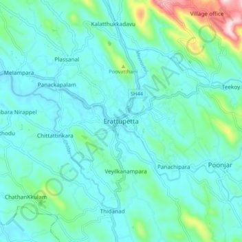
Name: Erattupetta topographic map, elevation, terrain.
Location: Erattupetta, Meenachil, Kottayam, Kerala, 686122, India (9.64799 76.73977 9.72799 76.81977)
Average elevation: 78 m
Minimum elevation: 10 m
Maximum elevation: 415 m
Thank you for supporting this site ❤️
Make a donation
Make a donation
Other topographic maps
Click on a map to view its topography, its elevation and its terrain.
Cherppungal Kulam Cheripurathu Padasekaram Karikombu
India > Kerala > Meenachil > Cherpunkal
Average elevation: 29 m
Thank you for supporting this site ❤️
Make a donation
Make a donation