
Kurunegala District topographic map
Interactive map
Click on the map to display elevation.
About this map
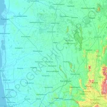
Name: Kurunegala District topographic map, elevation, terrain.
Location: Kurunegala District, North Western Province, Sri Lanka (7.25789 79.90050 8.19780 80.57792)
Average elevation: 137 m
Minimum elevation: 0 m
Maximum elevation: 1,573 m
Other topographic maps
Click on a map to view its topography, its elevation and its terrain.
Feeder Canal to Bathalagoda Lake from Daduru Oya Anicut
Sri Lanka > North Western Province > Kurunegala
Average elevation: 127 m