
Bandung topographic map
Interactive map
Click on the map to display elevation.
About this map
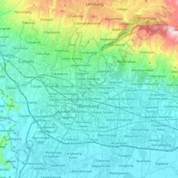
Name: Bandung topographic map, elevation, terrain.
Location: Bandung, West Java, Jawa, Indonesia (-6.96975 107.54536 -6.83685 107.73952)
Average elevation: 824 m
Minimum elevation: 642 m
Maximum elevation: 1,624 m
Bandung (Sundanese: ᮘᮔ᮪ᮓᮥᮀ, romanized: Bandung, Sundanese pronunciation: [ˈbandʊŋ]; /ˈbɑːndʊŋ/) is the capital city of the Indonesian province of West Java. It has a population of 2,452,943 within its city limits according to the official estimates as at mid 2021, making it the fourth most populous city in Indonesia. Greater Bandung (Bandung Basin Metropolitan Area/BBMA) is the country's second-largest metropolitan area, with over 11 million inhabitants. Located 768 metres (2,520 feet) above sea level, the highest point in the North area with an altitude of 1,050 meters and the lowest in the South is 675 meters above sea level, approximately 140 kilometres (87 miles) southeast of Jakarta, Bandung has cooler year-round temperatures than most other Indonesian cities. The city lies on a river basin surrounded by volcanic mountains that provides a natural defence system, which was the primary reason for the Dutch East Indies government's plan to move the capital from Batavia (modern-day Jakarta) to Bandung.
Other topographic maps
Click on a map to view its topography, its elevation and its terrain.
Hutan Kota Patriot Bina Bangsa Kota Bekasi
Indonesia > West Java > Bekasi > Kayuringinjaya
Hutan Kota Patriot Bina Bangsa Kota Bekasi, Kranji, Proyek, Kayuringinjaya, Bekasi, West Java, Java, Indonesia
Average elevation: 19 m
Kertamulya
Indonesia > West Java > Bandung Barat
Kertamulya, Bandung Barat, West Java, Java, 40552, Indonesia
Average elevation: 706 m
Lebak Siliwangi
Indonesia > West Java > Bandung
Lebak Siliwangi, Coblong, Bandung, West Java, Java, 40132, Indonesia
Average elevation: 763 m
Conggeang Kulon
Indonesia > West Java > Sumedang
Conggeang Kulon, Sumedang, West Java, Indonesia
Average elevation: 409 m
Jatimekar
Indonesia > West Java > Kota Bekasi
Jatimekar, Kota Bekasi, West Java, 17422, Indonesia
Average elevation: 33 m
Bogor Botanical Gardens
Indonesia > West Java > Bogor > Tegal Gundil
Bogor Botanical Gardens, Tegal Gundil, Bogor, West Java, Indonesia
Average elevation: 256 m
Karang Asem Timur
Karang Asem Timur, West Java, 16911, Indonesia
Average elevation: 140 m
Depok Lama
Depok Lama, Depok, West Java, 16434, Indonesia
Average elevation: 88 m
Margahayu Tengah
Margahayu Tengah, West Java, 40228, Indonesia
Average elevation: 671 m
Sukabungah
Sukabungah, Sukasari, West Java, 40161, Indonesia
Average elevation: 757 m
Majalengka Regency
Majalengka Regency, West Java, Indonesia
Average elevation: 334 m
Gunung Argapura
Gunung Argapura, Majalengka Regency, West Java, Indonesia
Average elevation: 1,831 m