
Thank you for supporting this site ❤️
Make a donation
Make a donation
Margahayu Tengah topographic map
Click on the map to display elevation.
Thank you for supporting this site ❤️
Make a donation
Make a donation
About this map
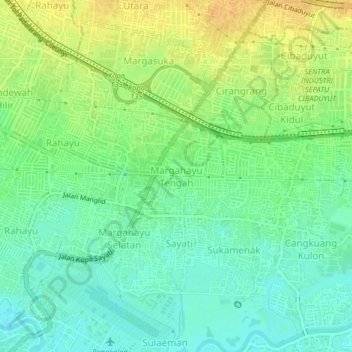
Name: Margahayu Tengah topographic map, elevation, terrain.
Location: Margahayu Tengah, West Java, 40228, Indonesia (-6.98694 107.55834 -6.94694 107.59834)
Average elevation: 671 m
Minimum elevation: 657 m
Maximum elevation: 690 m
Thank you for supporting this site ❤️
Make a donation
Make a donation
Other topographic maps
Click on a map to view its topography, its elevation and its terrain.
Thank you for supporting this site ❤️
Make a donation
Make a donation
Thank you for supporting this site ❤️
Make a donation
Make a donation
Hutan Kota Patriot Bina Bangsa Kota Bekasi
Indonesia > West Java > Bekasi > Kayuringinjaya
Average elevation: 19 m
Thank you for supporting this site ❤️
Make a donation
Make a donation
Thank you for supporting this site ❤️
Make a donation
Make a donation