
Make a donation
Macedonia and Thrace topographic map
Click on the map to display elevation.
Make a donation
About this map
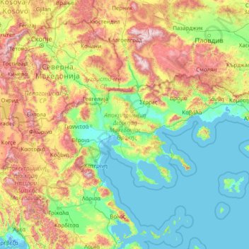
Name: Macedonia and Thrace topographic map, elevation, terrain.
Location: Macedonia and Thrace, Greece (39.83097 21.70420 41.74889 26.63558)
Average elevation: 526 m
Minimum elevation: -4 m
Maximum elevation: 2,848 m
Make a donation
Other topographic maps
Click on a map to view its topography, its elevation and its terrain.
Kavala
Greece > Macedonia and Thrace > Kavala Regional Unit
On July 16, 2022, Meridian Flight 3032 crashed nearby. The Ukrainian-registered Antonov An-12BK was carrying 11.5 tons of ammunition from Niš to Dhaka when the plane began to lose altitude over the Aegean and turned around, but went down 35 kilometers west of Kavala Airport. All 8 crew members were killed.
Average elevation: 173 m
Karya
Greece > Peloponnese, Western Greece and the Ionian > Lefkada Regional Unit > Municipal Unit of Karya
Average elevation: 593 m
Make a donation
Καλλιθέα
Greece > Macedonia and Thrace > Chalkidiki Regional Unit > Kassandra Municipal Unit
Average elevation: 25 m
Make a donation
Mesolongi
Greece > Peloponnese, Western Greece and the Ionian > Aetolia-Acarnania Regional Unit
Average elevation: 108 m
Ελίτσα
Greece > Thessaly and Central Greece > Regional Unit of Magnesia > Municipal Unit of Zagora > Πουρί
Average elevation: 183 m
Tigania Beach
Greece > Macedonia and Thrace > Chalkidiki Regional Unit > Toroni Municipal Unit
Average elevation: 11 m
Make a donation
Δορούφι Κοιλάδος
Greece > Peloponnese, Western Greece and the Ionian > Argolis Regional Unit > Municipal Unit of Kranidi
Average elevation: 30 m
Make a donation
Corfu
Greece > Peloponnese, Western Greece and the Ionian > Corfu Regional Unit
Average elevation: 67 m
Make a donation
Pylos
Greece > Peloponnese, Western Greece and the Ionian > Messenia Regional Unit
The erection of this fort led to one of the most memorable events in the Peloponnesian War. Thucydides has given a minute account of the topography of the district, which, though clear and consistent with itself, does not coincide, in all points, with the existing locality, Thucydides describes the harbour, of…
Average elevation: 79 m
Fteri
Greece > Thessaly and Central Greece > Phthiotis Regional Unit > Municipal Unit of Sperchiada
Average elevation: 421 m
Αγία Παρασκευή
Greece > Macedonia and Thrace > Chalkidiki Regional Unit > Pallini Municipal Unit
Average elevation: 165 m
Monemvasia
Greece > Peloponnese, Western Greece and the Ionian > Laconia Regional Unit
Average elevation: 7 m
Make a donation
Olympia
Greece > Peloponnese, Western Greece and the Ionian > Elis Regional Unit > Ancient Olympia
Average elevation: 57 m
Make a donation
Βάρδα
Greece > Peloponnese, Western Greece and the Ionian > Elis Regional Unit
Average elevation: 20 m
Margelion
Greece > Region of Crete > Lasithi Regional Unit > Agios Nikolaos Municipal Unit
Average elevation: 293 m