
Thank you for supporting this site ❤️
Make a donation
Make a donation
Kavala topographic map
Click on the map to display elevation.
Thank you for supporting this site ❤️
Make a donation
Make a donation
Kavala
On July 16, 2022, Meridian Flight 3032 crashed nearby. The Ukrainian-registered Antonov An-12BK was carrying 11.5 tons of ammunition from Niš to Dhaka when the plane began to lose altitude over the Aegean and turned around, but went down 35 kilometers west of Kavala Airport. All 8 crew members were killed.
Thank you for supporting this site ❤️
Make a donation
Make a donation
About this map
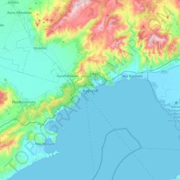
Name: Kavala topographic map, elevation, terrain.
Average elevation: 173 m
Minimum elevation: -3 m
Maximum elevation: 984 m
Thank you for supporting this site ❤️
Make a donation
Make a donation