
Βάρδα topographic map
Interactive map
Click on the map to display elevation.
About this map
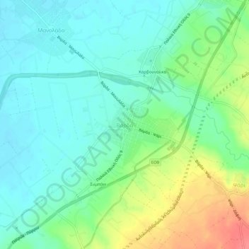
Name: Βάρδα topographic map, elevation, terrain.
Average elevation: 20 m
Minimum elevation: 0 m
Maximum elevation: 64 m
Other topographic maps
Click on a map to view its topography, its elevation and its terrain.
Olympia
Greece > Peloponnese, Western Greece and the Ionian > Elis Regional Unit > Ancient Olympia
Olympia, Ancient Olympia, Municipality of Ancient Olympia, Elis Regional Unit, Western Greece, Peloponnese, Western Greece and the Ionian, 27065, Greece
Average elevation: 57 m