
Κάτω Σχολάρι topographic map
Interactive map
Click on the map to display elevation.
About this map
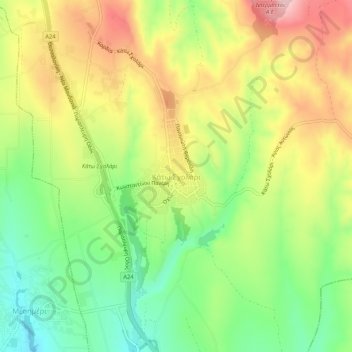
Name: Κάτω Σχολάρι topographic map, elevation, terrain.
Average elevation: 181 m
Minimum elevation: 83 m
Maximum elevation: 295 m
Other topographic maps
Click on a map to view its topography, its elevation and its terrain.
Thessaloniki
Greece > Macedonia and Thrace > Thessaloniki Regional Unit
Thessaloniki, Thessaloniki Municipal Unit, Municipality of Thessaloniki, Thessaloniki Regional Unit, Central Macedonia, Macedonia and Thrace, 546 26, Greece
Average elevation: 126 m