
Make a donation
Pylos topographic map
Click on the map to display elevation.
Make a donation
Pylos
The erection of this fort led to one of the most memorable events in the Peloponnesian War. Thucydides has given a minute account of the topography of the district, which, though clear and consistent with itself, does not coincide, in all points, with the existing locality, Thucydides describes the harbour, of which the promontory Coryphasium (Koryphasion) formed the northern termination, as fronted and protected by the island Sphacteria, which stretched along the coast, leaving only two narrow entrances to the harbour,--the one at the northern end, opposite to Coryphasium, being only wide enough to admit two triremes abreast, and the other at the southern end wide enough for eight or nine triremes. The island was about 15 stadia in width, covered with wood, uninhabited and untrodden. Pausanias also says that the island Sphacteria lies before the harbour of Pylos like Rheneia before the anchorage of Delos. A little later the Athenians captured a number of Spartan troops besieged on the adjacent island of Sphacteria (see Battle of Sphacteria). Spartan anxiety over the return of the prisoners, who were taken to Athens as hostages, contributed to their acceptance of the Peace of Nicias in 421 BC.
Make a donation
About this map
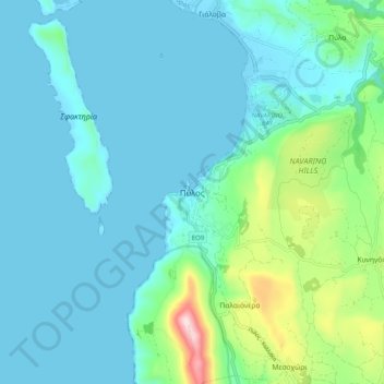
Name: Pylos topographic map, elevation, terrain.
Average elevation: 79 m
Minimum elevation: -6 m
Maximum elevation: 475 m
Make a donation