
Make a donation
Matigara block topographic map
Click on the map to display elevation.
Make a donation
About this map
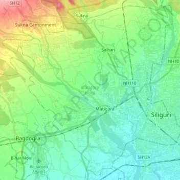
Name: Matigara block topographic map, elevation, terrain.
Location: Matigara block, Darjeeling district, West Bengal, India (26.67120 88.29875 26.79794 88.44852)
Average elevation: 139 m
Minimum elevation: 104 m
Maximum elevation: 236 m
Make a donation
Other topographic maps
Click on a map to view its topography, its elevation and its terrain.
Kolkata
Spread roughly north–south along the east bank of the Hooghly River, Kolkata sits within the lower Ganges Delta of eastern India approximately 75 km (47 mi) west of the international border with Bangladesh; the city's elevation is 1.5–9 m (5–30 ft). Much of the city was originally a wetland that was…
Average elevation: 5 m
Siliguri
India > West Bengal > Matigara block
Siliguri located at the foothills of the eastern Himalayas at a location of 26°43′N 88°26′E / 26.71°N 88.43°E / 26.71; 88.43. This city is spread over an area of 260 km2 within the Siliguri Corridor, also known as the Chicken's neck. The city is surrounded by dense forests towards north and…
Average elevation: 121 m
Make a donation
Make a donation
Kharagpur
India > West Bengal > Kharagpur-I
Kharagpur is the fourth largest city of West Bengal in area after Kolkata, Durgapur and Asansol. It is also the fifth most populated city of West Bengal after Kolkata, Asansol, Siliguri, Durgapur - located at 22°19′49″N 87°19′25″E / 22.330239°N 87.323653°E / 22.330239; 87.323653, covering…
Average elevation: 39 m
Chakdaha
India > West Bengal > Chakdaha
Chakdaha is a prominent urban local body in the district of Nadia, one of the southern districts of West Bengal. Chakdaha's location is 23°05′N 88°31′E / 23.08°N 88.52°E / 23.08; 88.52. It has an average elevation of 11 meters (36 feet) and is 62 km north of the state capital, Kolkata. It is…
Average elevation: 10 m
Make a donation
Malda
India > West Bengal > English Bazar
Malda is located at 25°00′43″N 88°08′36″E / 25.0119°N 88.1433°E / 25.0119; 88.1433. It has an average elevation of 17 metres (56 feet). It is situated on both the western and eastern banks of the river Mahananda.
Average elevation: 26 m
Krishnanagar
India > West Bengal > Krishnagar-I
Krishnanagar is located at 23°24′N 88°30′E / 23.4°N 88.5°E / 23.4; 88.5. The area of the municipality is around 16 km2. It is situated on the southern banks of the Jalangi River. It has an average elevation of 14 metres (46 ft). The Tropic of Cancer passes through the outskirts of…
Average elevation: 11 m
Make a donation
Haldia
India > West Bengal > Haldia
Haldia is located at 22°02′N 88°04′E / 22.03°N 88.06°E / 22.03; 88.06. It has an average elevation of 8 metres (26 ft).
Average elevation: 3 m
Digha
India > West Bengal > Digha
Digha is located at 21°38′18″N 87°30′35″E / 21.6384°N 87.5096°E / 21.6384; 87.5096. It has an average elevation of 6 metres (20 ft).
Average elevation: 4 m
Dhupguri
India > West Bengal > Dhupguri
Dhupguri has an average elevation of 80 metres (262 feet), and is a municipality in the Jalpaiguri district. In the foothills of the Bhutanese Himalayas, the Jaldhaka River flows through the west of the town. The Daina, Gilandi, Duduya, Kumlai, Jhumur, and Bamni are other rivers which flow through the town.
Average elevation: 77 m
Make a donation
Cooch Behar
India > West Bengal > Cooch Behar
The elevation of the town is 48 meters above mean sea level.
Average elevation: 43 m
Make a donation
Debagram
India > West Bengal > Kaliganj
Debagram is a part of deltaic alluvial plain of west Bengal formed by river Ganga and its tributaries and distributaries. It has an average elevation of 18 meters. This flat area is characterized by some ponds and low lands. The nearest river of the village is the Bhagirathi. It is about 9 km away from the…
Average elevation: 16 m
Make a donation
Uluberia
India > West Bengal > Uluberia - I
Uluberia is located at 22°28′N 88°07′E / 22.47°N 88.11°E / 22.47; 88.11. It has an average elevation of 1 m (3.3 ft). It is situated on the banks of the river Hooghly. The main road passing through the heart of the city is Orissa trunk road and is also well connected by National Highway 16.…
Average elevation: 5 m
Make a donation
Pujali
India > West Bengal > Budge Budge - I > Pujali
Pujali is located at 22°28′04″N 88°08′43″E / 22.4678722°N 88.1452410°E / 22.4678722; 88.1452410. It has an average elevation of 9 metres (30 ft).
Average elevation: 5 m
Make a donation
Dankuni
India > West Bengal > Chanditala - II
Located at an elevation of None meters (0 feet) above sea level, city's yearly temperature is 30.28 °C (86.5 °F) and it is 4.31% higher than India's averages. Dankuni typically receives about 150.21 millimeters (5.91 inches) of precipitation and has 150.54 rainy days (41.24% of the time) annually.
Average elevation: 6 m
Diamond Harbour
India > West Bengal > Diamond Harbour - I
Diamond Harbour is located at 22°11′28″N 88°11′26″E / 22.1910091°N 88.1904741°E / 22.1910091; 88.1904741. It has an average elevation of 8 metres (26 ft).
Average elevation: 3 m
Karimpur
India > West Bengal > Karimpur-I
Karimpur is located at 23°58′N 88°37′E / 23.97°N 88.62°E / 23.97; 88.62. It has an average elevation of 15 metres (49 ft). It is 183 km (114 mi) from Kolkata and is located at the bank of the River Jalangi.
Average elevation: 18 m
Make a donation
Damdim
India > West Bengal > Mal
Dam Dim is located at 26°51′56″N 88°40′11″E / 26.8656°N 88.6698°E / 26.8656; 88.6698 at an elevation of 141 m above MSL.
Average elevation: 161 m
Make a donation
Dum Dum
India > West Bengal > Barrackpore
Dum Dum is located at 22°37′N 88°25′E / 22.62°N 88.42°E / 22.62; 88.42. It has an average elevation of 11 metres (36 feet).
Average elevation: 6 m
Make a donation
Bidhannagar
India > West Bengal > Bidhannagar
According to the Bidhannagar Municipal Corporation, the city area has a total area of 55.51 square kilometres (21.43 sq mi), with approx 30.51 square kilometres (11.78 sq mi) of it being land, and approx 25 square kilometres (9.7 sq mi), or 45.5% of the total, being covered by water. It has an average…
Average elevation: 5 m
Taki
India > West Bengal > Hasnabad
Taki is located at 22°35′N 88°55′E / 22.59°N 88.92°E / 22.59; 88.92. It has an average elevation of 5 metres (16 feet) at the bank of Ichamati River.
Average elevation: 4 m
Make a donation
Bangaon
India > West Bengal > Bongaon
Bangaon is located at 23°04′N 88°49′E / 23.07°N 88.82°E / 23.07; 88.82. It has an average elevation of 7 metres (22 feet). Arsenic contamination is a major concern in this area.
Average elevation: 7 m
Kakdwip
India > West Bengal > Kakdwip
Kakdwip is located at 21°52′45″N 88°11′29″E / 21.8791446°N 88.1912992°E / 21.8791446; 88.1912992. It has an average elevation of 4 metres (13 ft).
Average elevation: 3 m
Beldanga
India > West Bengal > Beldanga - I
Beldanga is located at 23°56′N 88°15′E / 23.93°N 88.25°E / 23.93; 88.25. It has an average elevation of 20 metres (65 feet).
Average elevation: 17 m
Make a donation
Make a donation
Make a donation
Make a donation
Jhargram
India > West Bengal > Jhargram
Jhargram is located at 22°27′N 86°59′E / 22.45°N 86.98°E / 22.45; 86.98. It has an average elevation of 81 metres (265 feet). The weather, like much of Bengal, is extremely humid and tropical. Temperatures can reach as high as 46 °C in the hot and dry months of May and June but can plummet to…
Average elevation: 79 m
Rajpur Sonarpur
India > West Bengal > Sonarpur
Rajpur Sonarpur is located at 22°26′18″N 88°25′55″E / 22.4382026°N 88.4320450°E / 22.4382026; 88.4320450. It has an average elevation of 9 metres (30 ft).
Average elevation: 4 m
Make a donation
Lava
India > West Bengal > Kalimpong - II
Lava (also known as Lava Bazar) is a town in the Kalimpong II CD block in the Kalimpong subdivision of the Kalimpong district in the Indian state of West Bengal. As it lies in the high altitude, so it is also visible from high altitude towns and villages of East Sikkim, high areas of Bhutan and also from…
Average elevation: 1,931 m
Mirik
India > West Bengal > Mirik Subdivision
Mirik has an average elevation of 1,495 m (4,905 ft). The highest point is the Bokar Monastery at about 1,768 m (5,801 ft). Mirik lake at about 1,494 m (4,902 ft) is the lowest point. Mirik is 52 km (32 mi) northwest of Siliguri city and 49 km (30 mi) south-southwest of Darjeeling town. Mirik subdivision. The…
Average elevation: 1,156 m
Make a donation
Baruipur
India > West Bengal > Baruipur
Baruipur is located at 22°21′56″N 88°25′57″E / 22.3654432°N 88.4325028°E / 22.3654432; 88.4325028. It has an average elevation of 9 metres (30 ft).
Average elevation: 7 m
Make a donation
Jaynagar Majilpur
India > West Bengal > Jaynagar - I
Jaynagar Majilpur is located at 22°10′31″N 88°25′12″E / 22.1751965°N 88.4200762°E / 22.1751965; 88.4200762. It has an average elevation of 8 metres (26 ft).
Average elevation: 5 m
Rishyap
India > West Bengal > Kalimpong - II
Rishyap is located at 27.03N & 88.18E. It has an average elevation of 2591 meters (8500 feet).
Average elevation: 1,789 m
Make a donation
Make a donation
Make a donation
Ilam Bazar
India > West Bengal > Illambazar
Ilambazar is located at 23°38′N 87°32′E / 23.63°N 87.53°E / 23.63; 87.53. It has an average elevation of 54 m (177 ft).
Average elevation: 58 m
Dalkola
India > West Bengal > Karandighi
Dalkhola has an average elevation of 23 meters (75 feet) and is located at 25°51′N 87°51′E / 25.85°N 87.85°E / 25.85; 87.85.
Average elevation: 38 m
Make a donation
Singur
India > West Bengal > Singur
Singur is located at 22°49′N 88°14′E / 22.81°N 88.23°E / 22.81; 88.23. It has an average elevation of 14 metres (45 ft), and is situated on the Ganges delta.
Average elevation: 9 m
Make a donation