
Make a donation
Bagdogra topographic map
Click on the map to display elevation.
Make a donation
About this map
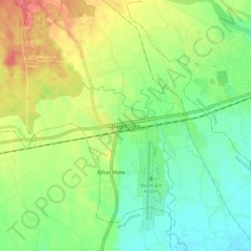
Name: Bagdogra topographic map, elevation, terrain.
Average elevation: 136 m
Minimum elevation: 110 m
Maximum elevation: 174 m
Make a donation
Other topographic maps
Click on a map to view its topography, its elevation and its terrain.
Siliguri
India > West Bengal > Siliguri Subdivsion
Siliguri is located at the foothills of the eastern Himalayas at a location of 26°43′N 88°26′E / 26.71°N 88.43°E / 26.71; 88.43. The city is spread over an area of 260 km2 (100 sq mi) within the Siliguri Corridor. The city is bordered by dense forests to the north and the Mahananda River flows…
Average elevation: 121 m
Siliguri
India > West Bengal > Siliguri Subdivsion
Siliguri is located at the foothills of the eastern Himalayas at a location of 26°43′N 88°26′E / 26.71°N 88.43°E / 26.71; 88.43. The city is spread over an area of 260 km2 (100 sq mi) within the Siliguri Corridor, and has earned a moniker the Chicken's neck. The city is surrounded by dense…
Average elevation: 121 m