Geolocate

Pfutsero topographic map

Interactive map

Click on the map to display elevation.

About this map

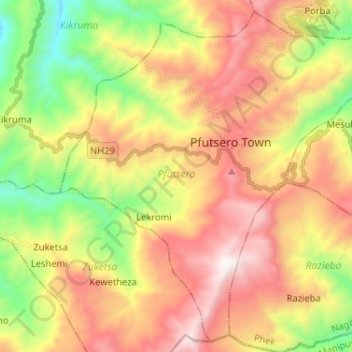
Name: Pfutsero topographic map, elevation, terrain.

Location: Pfutsero, Phek, Nagaland, 797107, India (25.50689 94.23659 25.61630 94.36586)

Average elevation: 1,720 m

Minimum elevation: 941 m

Maximum elevation: 2,534 m

Other topographic maps

Click on a map to view its topography, its elevation and its terrain.

Khonoma

India > Nagaland > Sechu-Zubza

Average elevation: 1,627 m

Jotsoma

India > Nagaland > Sechu-Zubza

Average elevation: 1,346 m

Rajbari

India > Nagaland > Chumukedima

Average elevation: 162 m

Chumukedima

India > Nagaland > Chumukedima

Average elevation: 251 m

Agri Expo

India > Nagaland > Chumukedima

Average elevation: 169 m

Piphema

India > Nagaland > Medziphema

Average elevation: 854 m

Nihokhu

India > Nagaland > Nihokhu

Average elevation: 214 m

Medziphema

India > Nagaland > Medziphema

Average elevation: 458 m

Jalukie

India > Nagaland > Jalukie

Average elevation: 338 m

Phek

India > Nagaland > Phek Sadar

Average elevation: 1,233 m

Enhulumi

India > Nagaland > Chizami

Average elevation: 1,396 m

Changki

India > Nagaland > Mangkolemba

Average elevation: 588 m

Phesama

India > Nagaland > Jakhama

Average elevation: 1,534 m

Kohima

India > Nagaland > Kohima Sadar

Kohima (/koʊˈhiːmə/ ; Angami Naga: Kewhira (IPA: [ˈkɛʍɪɻə]) is the capital of the Indian state of Nagaland. With a resident population of almost 100,000, it is the second largest city in the state. Kohima constitutes both a district and a municipality. The municipality covers 20 km2 (7.7 sq mi). The…

Average elevation: 1,425 m

Yimpang

India > Nagaland > Noklak

Average elevation: 2,034 m

Dimapur

India > Nagaland > Dimapur Sadar

Average elevation: 204 m

Dimapur

India > Nagaland > Dimapur

Average elevation: 156 m

Rangapahar WLS

India > Nagaland > Chumukedima

Average elevation: 159 m

Wokha

India > Nagaland

Average elevation: 719 m

Angola

India > Nagaland

Average elevation: 1,719 m

Zunheboto

India > Nagaland > Zunheboto

Average elevation: 1,010 m

Mon

India > Nagaland

Average elevation: 583 m

Doyang

India > Nagaland > Sanis > Sanis

Average elevation: 552 m

Viswema

India > Nagaland > Jakhama > Viswema

Average elevation: 1,530 m

Kohīma

India > Nagaland > Kohīma

Average elevation: 1,001 m

Kigwema Town

India > Nagaland > Jakhama

Average elevation: 1,688 m

town square

India > Nagaland > Chizami > town square

Average elevation: 1,324 m