Geolocate

Jabal al Akhdar topographic map

Interactive map

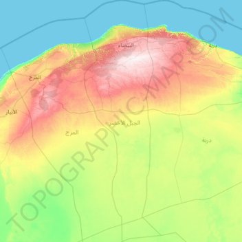
Click on the map to display elevation.

About this map

Name: Jabal al Akhdar topographic map, elevation, terrain.

Location: Jabal al Akhdar, Libya (31.06568 21.33192 33.14110 22.11252)

Average elevation: 201 m

Minimum elevation: -2 m

Maximum elevation: 871 m

In its southern part is the fertile upland area of Jebel Akhdar. North of this is a dry, sub-desert area between the uplands and the Mediterranean on its northern edge. Libya has mostly a flat undulating plain and occasional plateau, with an average elevation of around 423 m (1,388 ft). Around 91 per cent of the land is covered by desert, with only 8.8 per cent agricultural land (with only 1% arable lands) and 0.1 per cent of forests. The major resources are petroleum, gypsum and natural gas. Along the coastal regions, the climate is Mediterranean in coastal areas, while it is desert climate in all other parts. Dust storms lasting four to eight days is pretty common during Spring. Triplotania is the northwest region, while it is Cyrenacia in the east and Fezzen in southwest. Cyrenacia is the largest region in Libya, which is mostly semi arid in nature. The region receives an annual rainfall of 5 in (130 mm). There are no perennial rivers in the region, but the region is abundant with groundwater aquifers.

Wikipedia (CC-BY-SA 3.0)

Other topographic maps

Click on a map to view its topography, its elevation and its terrain.

Tripoli

Libya

Tripoli, Libya

Average elevation: 35 m

Darnah

Libya > Derna

Darnah, Derna, Libya

Average elevation: 85 m

Sirte

Libya > Sirte

Sirte, Libya

Average elevation: 23 m

Kufra

Libya

Kufra, Libya

Average elevation: 555 m

Sirte

Libya

Sirte, Libya

Average elevation: 162 m

Marj

Libya

Marj, Libya

Average elevation: 191 m

Jafara

Libya

Jafara, Libya

Average elevation: 117 m

Murqub

Libya

Murqub, Libya

Average elevation: 151 m

Nuqat al Khams

Libya

Nuqat al Khams, Libya

Average elevation: 37 m

Butnan

Libya

Butnan, Libya

Average elevation: 111 m

Al Qubbah

Libya > Derna

Al Qubbah, Derna, Libya

Average elevation: 585 m

Bani Walid

Libya > Bani Walid

Bani Walid, Libya

Average elevation: 250 m

Az Zawiya District

Libya

Az Zawiya District, Libya

Average elevation: 77 m

Al Zawiyah

Libya > Az Zawiya District

Al Zawiyah, Az Zawiya District, Libya

Average elevation: 31 m

Ghat

Libya > Ghat

Ghat, Libya

Average elevation: 784 m

Benghazi

Libya > Benghazi

Benghazi, 10001, Libya

Average elevation: 23 m

Bayda

Libya > Jabal al Akhdar > Bayda

Bayda, Jabal al Akhdar, Libya

Average elevation: 504 m

Ghadames

Libya > Nalut

Ghadames, Nalut, Libya

Average elevation: 331 m

Marawah

Libya > Jabal al Akhdar > Marawah

Marawah, Jabal al Akhdar, Libya

Average elevation: 481 m

Sabha

Libya > Sabha > Sabha

Sabha, 90.07.004, Libya

Average elevation: 434 m

Bardia

Libya > Butnan > Bardia

Bardia, Butnan, Libya

Average elevation: 81 m