
Thank you for supporting this site ❤️
Make a donation
Make a donation
Az Zawiya District topographic map
Click on the map to display elevation.
Thank you for supporting this site ❤️
Make a donation
Make a donation
About this map
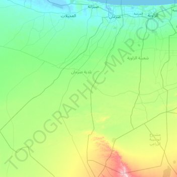
Name: Az Zawiya District topographic map, elevation, terrain.
Location: Az Zawiya District, Libya (32.19210 12.45564 33.01784 12.83959)
Average elevation: 77 m
Minimum elevation: -4 m
Maximum elevation: 657 m
Thank you for supporting this site ❤️
Make a donation
Make a donation
Other topographic maps
Click on a map to view its topography, its elevation and its terrain.
Thank you for supporting this site ❤️
Make a donation
Make a donation
Benghazi
The largest Ottoman architectural monument in Benghazi is the late 19th-century Ottoman palace in El-Berka; built during the rule of Rashid Pasha II. The front elevation was completed in 1895, whilst the side sections were added later during Italian rule. The white and green structure houses 360 rooms; and is…
Average elevation: 23 m