
Nuqat al Khams topographic map
Interactive map
Click on the map to display elevation.
About this map
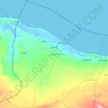
Name: Nuqat al Khams topographic map, elevation, terrain.
Location: Nuqat al Khams, Libya (32.26798 11.42111 33.35459 12.58919)
Average elevation: 37 m
Minimum elevation: -5 m
Maximum elevation: 274 m
In the north, Nuqat al Khams has a shoreline on the Mediterranean Sea. To the west, it borders the Medenine Governorate of Tunisia. Domestically, it borders Zawiya in the east, Jabal al Gharbi in the southeast and Nalut in the southwest. Nuqat al Khams is a part of Triplotania geographical region of Libya that runs from north to south. It has a set of coastal oases, plains, and limestone plateaus having an elevation of 2,000 ft (610 m) to 3,000 ft (910 m). The region receives an annual rainfall of 16 in (410 mm). There are no perennial rivers in the region, but groundwater aquifers are abundant. Along the coastal region, the climate is Mediterranean; elsewhere, it is desert. Dust storms lasting four to eight days are common during spring. The northwest region of Libya including Nuqat al Khams is called Tripolitania, the east is referred to as Cyrenaica, and Fezzen is in the southwest.
Other topographic maps
Click on a map to view its topography, its elevation and its terrain.