
Make a donation
Tripoli topographic map
Click on the map to display elevation.
Make a donation
Tripoli
The district has a shoreline along the coast of the Mediterranean Sea in the north (Gulf of Tripoli). On land it borders the following districts, namely, Zawiya in the west, Jafara in the southwest, Jabal al Gharbi in the south and Murqub in the east. Tripoli district is a part of Triplotania geographical region of Libya that runs from north to south and has set of coastal oases, plains and limestone plateaus having an elevation of 2,000 ft (610 m) to 3,000 ft (910 m). The region receives an annual rainfall of 16 in (410 mm). There are no perennial rivers in the region, but the region is abundant with groundwater aquifers. Libya has mostly a flat undulating plain and occasional plateau, with an average elevation of around 423 m (1,388 ft). Around 91 per cent of the land is covered by desert, with only 8.8 per cent agricultural land (with only 1% arable lands) and 0.1 per cent of forests. Along the coastal regions, the climate is Mediterranean, while it is desert climate in all other parts. Dust storms lasting four to eight days is pretty common during Spring. Triplotania is the northwest region, while it is Cyrenacia in the east and Fezzen in southwest.
Make a donation
About this map
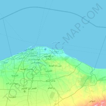
Name: Tripoli topographic map, elevation, terrain.
Location: Tripoli, Libya (32.62531 13.00937 33.12164 13.68859)
Average elevation: 35 m
Minimum elevation: -4 m
Maximum elevation: 343 m
Make a donation
Other topographic maps
Click on a map to view its topography, its elevation and its terrain.
Make a donation
Benghazi
The largest Ottoman architectural monument in Benghazi is the late 19th-century Ottoman palace in El-Berka; built during the rule of Rashid Pasha II. The front elevation was completed in 1895, whilst the side sections were added later during Italian rule. The white and green structure houses 360 rooms; and is…
Average elevation: 23 m