
Make a donation
Model Town Tehsil topographic map
Click on the map to display elevation.
Make a donation
About this map
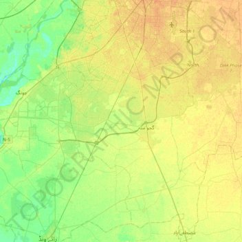
Name: Model Town Tehsil topographic map, elevation, terrain.
Average elevation: 210 m
Minimum elevation: 197 m
Maximum elevation: 221 m
Make a donation
Other topographic maps
Click on a map to view its topography, its elevation and its terrain.
Make a donation
Ravi River
Pakistan > Punjab > Yahya Nagar
The Ravi River originates in the Himalayas in the Multhan tehsil of Kangra district of Himachal Pradesh, India. It follows a north-westerly course and is a perennial river. It is the smallest of the five Punjab rivers that rise from glacier fields at an elevation of 14,000 feet (4,300 m), on the southern side…
Average elevation: 215 m
Murree
Pakistan > Punjab > Murree District
Murree (Punjabi, Urdu: مری) is a mountain resort city, located in the Galyat region of the Pir Panjal Range, within the Murree District of Punjab, Pakistan. It forms the outskirts of the Islamabad-Rawalpindi metropolitan area, and is about 30 km (19 mi) northeast of Islamabad. It has average altitude of…
Average elevation: 1,718 m
Make a donation
Make a donation
Rawalpindi
Pakistan > Punjab > Rawalpindi District > Rawalpindi Cantonment
Rawalpindi features a humid subtropical climate (Köppen: Cwa) with hot and wet summers, a cooler and drier winter. Rawalpindi and its twin city Islamabad, during the year experiences an average of 91 thunderstorms, which is the highest frequency of any plain elevation city in the country. Strong windstorms…
Average elevation: 530 m
Make a donation
Make a donation
Make a donation
Make a donation
Make a donation
Manglia
Manglia (Urdu: منگلیہ ) is a medium village of tehsil Kharian, District Gujrat, in the Punjab province of Pakistan. It is located at 32°86'N 73°97'E with an altitude of 271.5 metres). Manglia has many castes including Syed, Jutt, Awan, Malik, Mughal, and Kasbi. 32°52′N 73°59′E / 32.867°N…
Average elevation: 300 m
Make a donation
Make a donation
Make a donation
Make a donation
Make a donation