
Ambassa topographic map
Interactive map
Click on the map to display elevation.
About this map
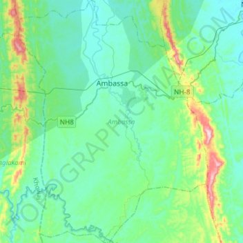
Name: Ambassa topographic map, elevation, terrain.
Location: Ambassa, Dhalai, Tripura, 799289, India (23.77498 91.75968 24.00115 91.95308)
Average elevation: 128 m
Minimum elevation: 47 m
Maximum elevation: 497 m
Other topographic maps
Click on a map to view its topography, its elevation and its terrain.
Haora River
Haora River, Agartala, West Tripura, Tripura, 799001, India
Average elevation: 18 m
Kailashahar
India > Tripura > Gournagar > Kailashahar
Kailashahar, Gournagar, Unokoti, Tripura, 799277, India
Average elevation: 33 m
South Tripura
India > Tripura > South Tripura
South Tripura, Gomati, Tripura, India
Average elevation: 75 m