
Unokoti topographic map
Interactive map
Click on the map to display elevation.
Unokoti
The topographic features seem to have influenced the climatic condition of the Unakoti district, where the plains are hotter and humid in comparison to the hills, which have a salubrious climate. The four main seasons here are
About this map
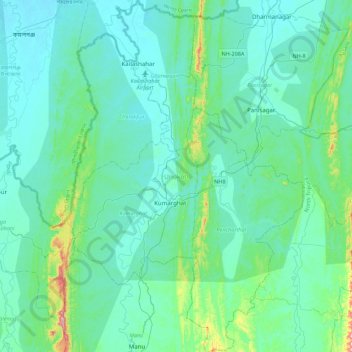
Name: Unokoti topographic map, elevation, terrain.
Location: Unokoti, Tripura, India (23.99051 91.90787 24.39156 92.20439)
Average elevation: 70 m
Minimum elevation: 17 m
Maximum elevation: 430 m
Other topographic maps
Click on a map to view its topography, its elevation and its terrain.
Amarpur
India > Tripura > Amarpur Urban
Amarpur is located at 23°32′N 91°38′E / 23.53°N 91.64°E / 23.53; 91.64. It has an average elevation of 24 metres (78 feet) above sea level. The town is connected to Udaipur and Teliamura with metalled roads. It can be accessed from the capital city of Agartala via Udaipur town. The nearest…
Average elevation: 54 m