
Sipahijala topographic map
Interactive map
Click on the map to display elevation.
About this map
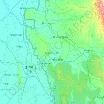
Name: Sipahijala topographic map, elevation, terrain.
Location: Sipahijala, Tripura, India (23.27475 91.15081 23.78680 91.56572)
Average elevation: 29 m
Minimum elevation: 2 m
Maximum elevation: 246 m
Other topographic maps
Click on a map to view its topography, its elevation and its terrain.
Amarpur
India > Tripura > Amarpur Urban
Amarpur is located at 23°32′N 91°38′E / 23.53°N 91.64°E / 23.53; 91.64. It has an average elevation of 24 metres (78 feet) above sea level. The town is connected to Udaipur and Teliamura with metalled roads. It can be accessed from the capital city of Agartala via Udaipur town. The nearest…
Average elevation: 54 m