
Make a donation
Mary Hill topographic map
Click on the map to display elevation.
Make a donation
About this map
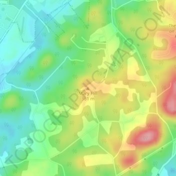
Name: Mary Hill topographic map, elevation, terrain.
Location: Mary Hill, Knox County, Tennessee, United States (35.98448 -83.76939 35.98458 -83.76929)
Average elevation: 320 m
Minimum elevation: 267 m
Maximum elevation: 397 m
Make a donation
Other topographic maps
Click on a map to view its topography, its elevation and its terrain.
Knoxville
United States > Tennessee > Knox County
According to the United States Census Bureau, the city has a total area of 104.2 square miles (269.8 km2), of which 98.5 square miles (255.2 km2) is land and 5.6 square miles (14.6 km2), or 5.42%, is water. Elevations range from just over 800 feet (240 m) along the riverfront to just over 1,000 feet (300 m) on…
Average elevation: 307 m
Make a donation
Chattanooga
United States > Tennessee > Hamilton County
According to the United States Census Bureau, the city has a total area of 144.6 square miles (374.4 km2), of which 137.1 square miles (355.2 km2) are land and 7.4 square miles (19.2 km2), or 5.12%, are water. The most prominent natural features in and around Chattanooga are the Tennessee River and the…
Average elevation: 331 m
Make a donation
Make a donation