
Thank you for supporting this site ❤️
Make a donation
Make a donation
Hamilton County topographic map
Click on the map to display elevation.
Thank you for supporting this site ❤️
Make a donation
Make a donation
About this map
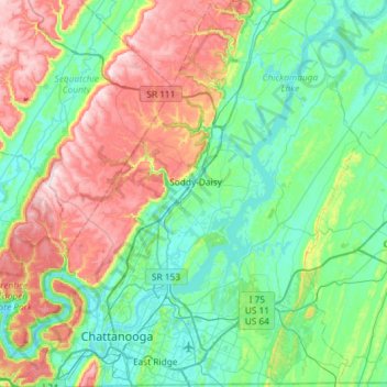
Name: Hamilton County topographic map, elevation, terrain.
Location: Hamilton County, East Tennessee, Tennessee, United States (34.98294 -85.47572 35.45917 -84.94266)
Average elevation: 340 m
Minimum elevation: 191 m
Maximum elevation: 724 m
Thank you for supporting this site ❤️
Make a donation
Make a donation
Other topographic maps
Click on a map to view its topography, its elevation and its terrain.