
Bezirk Bruck-Mürzzuschlag topographic map
Interactive map
Click on the map to display elevation.
About this map
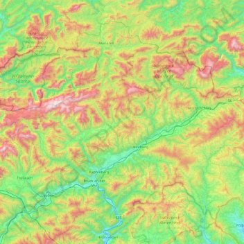
Name: Bezirk Bruck-Mürzzuschlag topographic map, elevation, terrain.
Location: Bezirk Bruck-Mürzzuschlag, Styria, Austria (47.30776 14.93149 47.82789 15.86234)
Average elevation: 1,007 m
Minimum elevation: 416 m
Maximum elevation: 2,245 m
Other topographic maps
Click on a map to view its topography, its elevation and its terrain.
Altaussee
Austria > Styria > Bezirk Liezen
Altaussee, Bezirk Liezen, Styria, 8992, Austria
Average elevation: 1,199 m
Kart
Austria > Styria > Bezirk Hartberg-Fürstenfeld > Unterneuberg
Kart, Unterneuberg, Pöllauberg, Bezirk Hartberg-Fürstenfeld, Styria, 8225, Austria
Average elevation: 453 m
Schöckl
Austria > Styria > Bezirk Graz-Umgebung > St. Radegund
Schöckl, St. Radegund, Bezirk Graz-Umgebung, Styria, 8061, Austria
Average elevation: 1,136 m
Sankt Gallen
Austria > Styria > Bezirk Liezen
Sankt Gallen, Bezirk Liezen, Styria, 8933, Austria
Average elevation: 924 m
Trofaiach
Austria > Styria > Bezirk Leoben
Trofaiach, Bezirk Leoben, Styria, 8793, Austria
Average elevation: 1,066 m
Schafberg
Austria > Styria > Bezirk Liezen > Liezen
Schafberg, Liezen, Bezirk Liezen, Styria, 8940, Austria
Average elevation: 1,591 m
Erzberg
Austria > Styria > Bezirk Leoben > Eisenerz
Erzberg, Eisenerz, Bezirk Leoben, Styria, 8790, Austria
Average elevation: 1,115 m
Gemeinde Spital am Semmering
Austria > Styria > Bezirk Bruck-Mürzzuschlag
Gemeinde Spital am Semmering, Bezirk Bruck-Mürzzuschlag, Styria, 8684, Austria
Average elevation: 1,158 m
Ramsau am Dachstein
Austria > Styria > Bezirk Liezen
Ramsau am Dachstein, Politische Expositur Gröbming, Bezirk Liezen, Styria, 8972, Austria
Average elevation: 1,526 m
Alm Rainer
Austria > Styria > Bezirk Murtal > Judenburg > Reifling
Alm Rainer, Reifling, Judenburg, Bezirk Murtal, Styria, 8750, Austria
Average elevation: 1,067 m
Schladming
Austria > Styria > Bezirk Liezen
Schladming, Politische Expositur Gröbming, Bezirk Liezen, Styria, 8970, Austria
Average elevation: 1,552 m
Fürstenfeld
Austria > Styria > Bezirk Hartberg-Fürstenfeld > Fürstenfeld
Fürstenfeld, Bezirk Hartberg-Fürstenfeld, Styria, 8280, Austria
Average elevation: 283 m
Zeltweg
Austria > Styria > Bezirk Murtal > Zeltweg
Zeltweg, Bezirk Murtal, Styria, 8740, Austria
Average elevation: 668 m
Salla
Austria > Styria > Bezirk Voitsberg > Salla
Salla, Maria Lankowitz, Bezirk Voitsberg, Styria, 8591, Austria
Average elevation: 1,055 m
Hohenfeld
Austria > Styria > Bezirk Deutschlandsberg > Hohenfeld
Hohenfeld, Bezirk Deutschlandsberg, Styria, 8524, Austria
Average elevation: 639 m
Bad Gleichenberg
Austria > Styria > Bezirk Südoststeiermark > Bad Gleichenberg
Bad Gleichenberg, Bezirk Südoststeiermark, Styria, 8344, Austria
Average elevation: 348 m
Klöch
Austria > Styria > Bezirk Südoststeiermark > Klöch
Klöch, Bezirk Südoststeiermark, Styria, 8493, Austria
Average elevation: 281 m
Gröbming
Austria > Styria > Bezirk Liezen > Gröbming
Gröbming, Politische Expositur Gröbming, Bezirk Liezen, Styria, 8962, Austria
Average elevation: 1,140 m
Sankt Martha
Austria > Styria > Bezirk Murtal > Sankt Marein-Feistritz > Sankt Martha
Sankt Martha, Sankt Marein-Feistritz, Bezirk Murtal, Styria, 8733, Austria
Average elevation: 745 m
Birkfeld
Austria > Styria > Bezirk Weiz > Birkfeld
Birkfeld, Bezirk Weiz, Styria, 8190, Austria
Average elevation: 862 m
Feldbach
Austria > Styria > Bezirk Südoststeiermark > Feldbach
Feldbach, Bezirk Südoststeiermark, Styria, 8330, Austria
Average elevation: 336 m
Koglhof
Austria > Styria > Bezirk Weiz > Koglhof
Koglhof, Birkfeld, Bezirk Weiz, Styria, 8190, Austria
Average elevation: 716 m
Vordernberg
Austria > Styria > Bezirk Leoben > Vordernberg
Vordernberg, Bezirk Leoben, Styria, 8794, Austria
Average elevation: 1,284 m
Hartberg
Austria > Styria > Bezirk Hartberg-Fürstenfeld > Hartberg
Hartberg, Bezirk Hartberg-Fürstenfeld, Styria, 8230, Austria
Average elevation: 409 m
Hofkirchen bei Hartberg
Austria > Styria > Bezirk Hartberg-Fürstenfeld > Hofkirchen bei Hartberg
Hofkirchen bei Hartberg, Kaindorf, Bezirk Hartberg-Fürstenfeld, Styria, 8224, Austria
Average elevation: 407 m
Mürzzuschlag
Austria > Styria > Bezirk Bruck-Mürzzuschlag
Mürzzuschlag, Bezirk Bruck-Mürzzuschlag, Styria, 8680, Austria
Average elevation: 979 m
Neufisching
Austria > Styria > Zeltweg > Neufisching
Neufisching, Zeltweg, Bezirk Murtal, Styria, 8740, Austria
Average elevation: 669 m
Konradgut
Austria > Styria > Sankt Georgen am Kreischberg > Konradgut
Konradgut, Sankt Georgen am Kreischberg, Bezirk Murau, Styria, 8861, Austria
Average elevation: 1,238 m
Grimming
Austria > Styria > Stainach-Pürgg
Grimming, Stainach-Pürgg, Liezen, Styria, 8950, Austria
Average elevation: 1,675 m
Leutschach an der Weinstraße
Austria > Styria > Leutschach an der Weinstraße
Leutschach an der Weinstraße, Leibnitz, Styria, 8463, Austria
Average elevation: 480 m
Bad Aussee
Austria > Styria > Bezirk Liezen
Bad Aussee, Bezirk Liezen, Styria, 8990, Austria
Average elevation: 1,181 m
Knittelfeld
Austria > Styria > Bezirk Murtal
Knittelfeld, Bezirk Murtal, Styria, 8720, Austria
Average elevation: 724 m
Bad Radkersburg
Austria > Styria > Bad Radkersburg
Bad Radkersburg, Südoststeiermark, Styria, 8490, Austria
Average elevation: 221 m
Feldkirchen bei Graz
Austria > Styria > Feldkirchen bei Graz
Feldkirchen bei Graz, Graz-Umgebung, Styria, 8073, Austria
Average elevation: 335 m
Bruck an der Mur
Austria > Styria > Bezirk Bruck-Mürzzuschlag
Bruck an der Mur, Bezirk Bruck-Mürzzuschlag, Styria, 8600, Austria
Average elevation: 827 m
Deutschlandsberg
Austria > Styria > Bezirk Deutschlandsberg
Deutschlandsberg, Bezirk Deutschlandsberg, Styria, Austria
Average elevation: 614 m
Mariazell
Austria > Styria > Bezirk Bruck-Mürzzuschlag > Mariazell
Mariazell, Bezirk Bruck-Mürzzuschlag, Styria, 8630, Austria
Average elevation: 1,124 m
Ettendorf bei Stainz
Austria > Styria > Bezirk Deutschlandsberg > Stainz
Ettendorf bei Stainz, Stainz, Bezirk Deutschlandsberg, Styria, 8510, Austria
Average elevation: 344 m
Spechtensee
Austria > Styria > Stainach-Pürgg
Spechtensee, Spechtenseerunde, Hechl, Stainach-Pürgg, Liezen, Styria, 8950, Austria
Average elevation: 1,190 m