
Niwari Tahsil topographic map
Interactive map
Click on the map to display elevation.
About this map
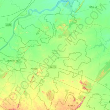
Name: Niwari Tahsil topographic map, elevation, terrain.
Location: Niwari Tahsil, Niwari District, Madhya Pradesh, India (25.22659 78.71211 25.55706 78.98912)
Average elevation: 226 m
Minimum elevation: 160 m
Maximum elevation: 394 m
Other topographic maps
Click on a map to view its topography, its elevation and its terrain.
Bhopal
India > Madhya Pradesh > Huzur Tahsil
Bhopal has an average elevation of 500 metres (1401 ft) and is located in the central part of India, just north of the upper limit of the Vindhya mountain ranges. Located on the Malwa plateau, it is higher than the north Indian plains and the land rises towards the Vindhya Range to the south. The city has…
Average elevation: 498 m
Indore
India > Madhya Pradesh > Juni Indore Tahsil
Indore /ɪnˈdɔːr/ (listen) is the most populous and the largest city in the Indian state of Madhya Pradesh. It serves as the headquarters of both Indore District and Indore Division. It is also considered as an education hub of the state and has campuses of both the Indian Institute of Technology and the…
Average elevation: 555 m
Ujjain
India > Madhya Pradesh > Ujjain NagarTahsil
Ujjain is located in the west-central part of India, and is north of the upper limit of the Vindhya mountain ranges. Located on the Malwa plateau, it is higher than the north Indian plains and the land rises towards the Vindhya Range to the south. Ujjain's co-ordinates are 23°10′N 75°46′E /…
Average elevation: 501 m
Gwalior
India > Madhya Pradesh > Gird Tahsil
Gwalior is located at 26°13′N 78°11′E / 26.22°N 78.18°E / 26.22; 78.18. in northern Madhya Pradesh 300 km (186 miles) from Delhi. It has an average elevation of 197 metres (646 feet). Most part of it comes under the Bundelkhand area.
Average elevation: 235 m
Bhopal
India > Madhya Pradesh > Huzur Tahsil
Bhopal has an average elevation of 500 metres (1401 ft) and is located in the central part of India, just north of the upper limit of the Vindhya mountain ranges. Located on the Malwa plateau, it is higher than the north Indian plains and the land rises towards the Vindhya Range to the south. The city has…
Average elevation: 498 m
Khandwa
India > Madhya Pradesh > Khandwa Nagar Tahsil
Khandwa is located at 21°50′N 76°20′E / 21.83°N 76.33°E / 21.83; 76.33. It has an average elevation of 313 metres (1026 feet).
Average elevation: 325 m
Siddheshwar Hanuman Mandir Udyaan
India > Madhya Pradesh > Juni Indore Tahsil > Indore
Average elevation: 550 m
Damoh
India > Madhya Pradesh > Danyantinagar Tahsil
Damoh is located at 23°53′N 79°27′E / 23.88°N 79.45°E / 23.88; 79.45. It is at an average elevation of 595 metres (1,952 ft).
Average elevation: 362 m
Umaria
India > Madhya Pradesh > Bandhogarh Umaria Tahsil
Umaria is located at 23°25′N 78°38′E / 23.42°N 78.63°E / 23.42; 78.63 and has an average elevation of 538 metres (1,765 feet).
Average elevation: 455 m
Jhabua
India > Madhya Pradesh > Jhabua Tahsil
Jhabua has an average elevation of 318 metres (1043 feet). Jhabua is located at the bottom left side of MP, mainly towards Gujarat.
Average elevation: 337 m
Sagar
India > Madhya Pradesh > Sagar Nagar Tahsil
Sagar has an average elevation of 427 metres (1401 ft) and is located in the central part of India, just north of the upper limit of the Vindhya mountain ranges.here is a lake in middle of the city.
Average elevation: 515 m