Geolocate

Lower Juba topographic map

Interactive map

Click on the map to display elevation.

About this map

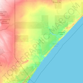
Name: Lower Juba topographic map, elevation, terrain.

Location: Lower Juba, Jubaland, JH 09010, Somalia (-1.80320 40.99326 1.32000 43.35697)

Average elevation: 40 m

Minimum elevation: -2 m

Maximum elevation: 168 m

Other topographic maps

Click on a map to view its topography, its elevation and its terrain.

Shire

Somalia > Bari > Qardho District

Average elevation: 695 m

Isha

Somalia > Bay > Baidoa District

Average elevation: 495 m

Kashida

Somalia > Bay > Baidoa District

Average elevation: 599 m

Garcad

Somalia > Mudug > Jariban District

Average elevation: 8 m

Bashka

Somalia > Mudug > Galdogob District

Average elevation: 395 m

Gal Dhuumood

Somalia > Mudug > Galdogob District

Average elevation: 374 m

Togdheer

Somalia > Togdheer > Burao District

Average elevation: 930 m

Cadad

Somalia > Galgaduud > Dhusamareb District

Average elevation: 125 m

Odweyne

Somalia > Togdheer > Odweyne

Average elevation: 1,050 m

Mogadishu

Somalia > Banaadir > Mogadishu

Average elevation: 55 m

Garoowe

Somalia > Nugaal > Garoowe

Garowe is situated in the Nugaal Valley, bounded by gradually ascending high plateaus that generally reach elevations of 500 to 1,000 metres (1,600 to 3,300 feet) above sea level on the north, west, and south. The western part of the same plateau is crossed by numerous valleys and dry watercourses. Goat and…

Average elevation: 486 m

Haji Ali

Somalia > Bakool > Haji Ali

Average elevation: 558 m