
New South Wales topographic map
Interactive map
Click on the map to display elevation.
New South Wales
New South Wales (NSW), located on Australia's eastern seaboard, boasts a diverse topography that significantly influences its landscapes and ecosystems. The state's eastern edge is dominated by a narrow coastal plain, featuring regions such as the Illawarra and Shoalhaven near Nowra, characterized by rolling hills and valleys. This coastal strip is flanked to the west by the Great Dividing Range, a series of mountain ranges, plateaus, and upland areas that extend over 3,500 kilometers (2,175 miles) along Australia's eastern coast. Within NSW, this range includes notable sections like the Blue Mountains, Southern Highlands, Central Tablelands, and Northern Tablelands, with many peaks exceeding 1,000 meters (3,281 feet) in elevation. The state's highest point, Mount Kosciuszko, rises to 2,228 (7,310 feet) meters within the Snowy Mountains, part of the Great Dividing Range. Westward, the terrain transitions into expansive agricultural plains, such as the Riverina region around Wagga Wagga, characterized by fertile soils and open landscapes. Further west, the Western Plains encompass nearly two-thirds of NSW, presenting arid to semi-arid conditions with vast, flat expanses and sparse vegetation.
About this map
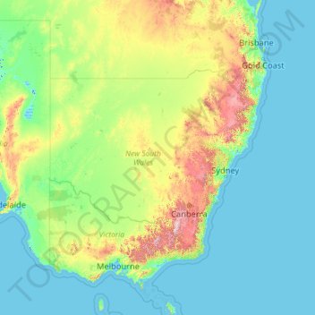
Name: New South Wales topographic map, elevation, terrain.
Location: New South Wales, Australia (-37.52801 140.99926 -28.14153 159.33903)
Average elevation: 154 m
Minimum elevation: -6 m
Maximum elevation: 2,129 m
Other topographic maps
Click on a map to view its topography, its elevation and its terrain.
Sunshine Coast
Australia > Queensland > Maroochydore
The Sunshine Coast in Queensland, Australia, showcases a diverse topography that harmoniously blends coastal plains with rugged hinterlands. Along its eastern edge, the region features expansive sandy beaches and coastal dunes that transition smoothly into fertile lowlands. Inland, the terrain becomes more…
Average elevation: 7 m
Gibson Desert
The Gibson Desert is located between the saline Kumpupintil Lake and Lake Macdonald along the Tropic of Capricorn, south of the Great Sandy Desert, east of the Little Sandy Desert, and north of the Great Victoria Desert. The altitude rises to just above 500 metres (1,600 ft) in places. As noted by early…
Average elevation: 464 m
Mount Wellington
"... In many parts the Eucalypti grew to a great size, and composed a noble forest. In some of the dampest ravines, tree-ferns flourished in an extraordinary manner; I saw one which must have been at least twenty feet high to the base of the fronds, and was in girth exactly six feet. The fronds forming the…
Average elevation: 941 m
Perth
Australia > Western Australia > City of Perth
Perth, the capital of Western Australia, is situated on the Swan Coastal Plain, a flat expanse of sandy soil nestled between the Indian Ocean to the west and the Darling Scarp to the east. The Darling Scarp, also known as the Darling Range, is a low escarpment that extends north–south, marking a distinct…
Average elevation: 26 m
Toowoomba
The city is situated on the edge of the range and the low ridges behind it. Two valleys extend north from the southern boundary, originating from springs on either side of Middle Ridge near Spring Street, at an altitude of approximately 680 metres (2,230 ft). These waterways, East Creek and West Creek,…
Average elevation: 458 m
Cairns
Australia > Queensland > Cairns
South of Smithfield and inland from the Northern Beaches along the edge of the Barron River flood plain are the suburbs of Caravonica, Kamerunga, Freshwater, and Stratford. This area is sometimes referred to as Freshwater Valley, though it is actually the lower part of Redlynch Valley; further up the valley…
Average elevation: 176 m