
Mayne topographic map
Click on the map to display elevation.
About this map
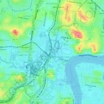
Name: Mayne topographic map, elevation, terrain.
Average elevation: 20 m
Minimum elevation: -2 m
Maximum elevation: 76 m
Other topographic maps
Click on a map to view its topography, its elevation and its terrain.
Whites Hill Reserve
Whites Hill is named after Robert (Bob) White, who, in 1873, acquired 21.5 hectares (53 acres) of land surrounding the 120 metres (390 ft) elevation now known as Whites Hill. Halfway up the hill facing Coorparoo, the White family built their family home. In 1886, White installed a powerful telescope, which he…
Average elevation: 48 m