
Toowoomba topographic map
Click on the map to display elevation.
Toowoomba
The city is situated on the edge of the range and the low ridges behind it. Two valleys extend north from the southern boundary, originating from springs on either side of Middle Ridge near Spring Street, at an altitude of approximately 680 metres (2,230 ft). These waterways, East Creek and West Creek, converge just north of the CBD to form Gowrie Creek.
About this map
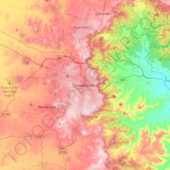
Name: Toowoomba topographic map, elevation, terrain.
Location: Toowoomba, Toowoomba Regional, Queensland, 4350, Australia (-27.72102 151.79335 -27.40102 152.11335)
Average elevation: 458 m
Minimum elevation: 126 m
Maximum elevation: 736 m
Other topographic maps
Click on a map to view its topography, its elevation and its terrain.
Whites Hill Reserve
Whites Hill is named after Robert (Bob) White, who, in 1873, acquired 21.5 hectares (53 acres) of land surrounding the 120 metres (390 ft) elevation now known as Whites Hill. Halfway up the hill facing Coorparoo, the White family built their family home. In 1886, White installed a powerful telescope, which he…
Average elevation: 48 m