
Kab Bekasi topographic map
Interactive map
Click on the map to display elevation.
About this map
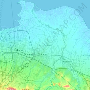
Name: Kab Bekasi topographic map, elevation, terrain.
Location: Kab Bekasi, West Java, Java, Indonesia (-6.48504 106.96877 -5.92031 107.29662)
Average elevation: 21 m
Minimum elevation: -4 m
Maximum elevation: 323 m
Other topographic maps
Click on a map to view its topography, its elevation and its terrain.
Hutan Kota Patriot Bina Bangsa Kota Bekasi
Indonesia > West Java > Bekasi > Kayuringinjaya
Average elevation: 19 m