
Make a donation
Maharashtra topographic map
Click on the map to display elevation.
Make a donation
Maharashtra
Maharashtra with a total area of 307,713 km2 (118,809 sq mi), is the third-largest state by area in terms of land area and constitutes 9.36 per cent of India's total geographical area. The State lies between 15°35' N to 22°02' N latitude and 72°36' E to 80°54' E longitude. It occupies the western and central part of the country and has a coastline stretching 840 kilometres along the Arabian Sea. The dominant physical feature of the state is its plateau character, which is separated from the Konkan coastline by the mountain range of the Western Ghats, which runs parallel to the coast from north to south.The Western Ghats, also known as the Sahyadri Range, has an average elevation of 1,200 metres (4,000 ft); its slopes gently descending towards the east and southeast. The Western Ghats (or the Sahyadri Mountain range) provide a physical barrier to the state on the west, while the Satpura Hills along the north and Bhamragad-Chiroli-Gaikhuri ranges on the east serve as its natural borders. This state's expansion from North to South is 700 km and East to West is 800 km. To the west of these hills lie the Konkan coastal plains, 50–80 kilometres in width. To the east of the Ghats lies the flat Deccan Plateau. The main rivers of the state are the Krishna, and its tributary, Bhima, the Godavari, and its main tributaries, Manjara, and Wardha-Wainganga and the Tapi, and its tributary Purna. Maharashtra is divided into five geographic regions. Konkan is the western coastal region, between the Western Ghats and the sea. Khandesh is the north region lying in the valley of the Tapti, Purna river. Nashik, Malegaon Jalgaon, Dhule and Bhusawal are the major cities of this region. Desh is in the center of the state. Marathwada, which was a part of the princely state of Hyderabad until 1956, is located in the southeastern part of the state. Aurangabad and Nanded are the main cities of the region. Vidarbha is the easternmost region of the state, formerly part of the Central Provinces and Berar.
Make a donation
About this map
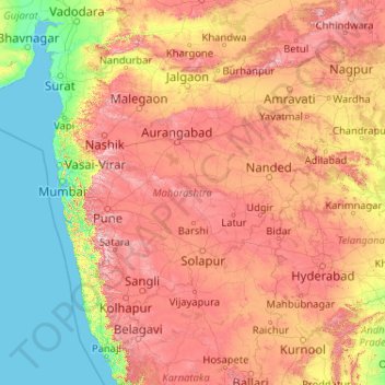
Name: Maharashtra topographic map, elevation, terrain.
Location: Maharashtra, India (15.60636 72.65261 22.03027 80.89778)
Average elevation: 346 m
Minimum elevation: -1 m
Maximum elevation: 1,418 m
Make a donation
Other topographic maps
Click on a map to view its topography, its elevation and its terrain.
Maharashtra
Maharashtra is the third largest state by area in India. The Western Ghats better known as Sahyadri, are a hilly range running parallel to the coast, at an average elevation of 1,200 metres (4,000 ft). Kalsubai, a peak in the Sahyadris, near Nashik city is the highest elevated point in Maharashtra. To the west…
Average elevation: 478 m
Make a donation
Bhavnagar
India > Gujarat > Bhavnagar Taluka
Bhavnagar is a coastal city on the eastern coast of Saurashtra, also known as Kathiawar, located at 21°46′N 72°09′E / 21.77°N 72.15°E / 21.77; 72.15. It has an average elevation of 24 metres (78 ft). It occupies an area of 53.3 km2 (20.6 sq mi) and 5th most populated city of Gujarat. The…
Average elevation: 23 m
Ludhiana
India > Punjab > Ludhiana (West) Tahsil
Ludhiana is located at 30°54′N 75°51′E / 30.9°N 75.85°E / 30.9; 75.85. It has an average elevation of 244 metres (801 ft). Ludhiana City, to its residents, consists of the Old City and the New City. The new city primarily consists of the Civil Lines area which was historically known as the…
Average elevation: 247 m
Make a donation
Make a donation
Chennai
Chennai is located on the south–eastern coast of India in the north–eastern part of Tamil Nadu on a flat coastal plain known as the Eastern Coastal Plains. Its average elevation is around 6.7 metres (22 ft), and its highest point is 60 m (200 ft). Chennai is 2,184 kilometres (1,357 mi) south of Delhi,…
Average elevation: 7 m
Make a donation
Bhubaneshwar
India > Odisha > Bhubaneswar (M.Corp.)
Bhubaneswar is in Khordha district of Odisha. It is in the eastern coastal plains, along the axis of the Eastern Ghats mountains. The city has an average altitude of 45 m (148 ft) above sea level. It lies southwest of the Mahanadi River that forms the northern boundary of Bhubaneswar metropolitan area, within…
Average elevation: 30 m
Make a donation
Thiruvananthapuram
India > Kerala > Thiruvananthapuram
Thiruvananthapuram is built on seven hills by the seashore and is at 8°30′N 76°54′E / 8.5°N 76.9°E / 8.5; 76.9 on the west coast, near the southern tip of mainland India. The city is on the west coast of India and is bounded by the Laccadive Sea to its west and the Western Ghats to its east.…
Average elevation: 33 m
Mumbai
Mumbai lies at the mouth of the Ulhas River on the western coast of India, in the coastal region known as the Konkan. It sits on Salsette Island (Sashti Island), which it partially shares with the Thane district. Mumbai is bounded by the Arabian Sea to the west. Many parts of the city lie just above sea level,…
Average elevation: 13 m
Make a donation
Kotdwar
India > Uttarakhand > Kotdwara
Kotdwar lies on the western margin of the Himalayas, at an altitude of 454 m (1,490 ft) above sea level.
Average elevation: 471 m
Niphad
India > Maharashtra > Niphad Taluka
Niphad is the name both of the town and the Taluka headquartered there. It is within the Nashik District of Maharashtra, India. The Marathi name signifies "a place without mountains", and indeed the taluka's topography is fairly level, with hardly any hills. It is served by Niphad railway station. Niphad's…
Average elevation: 550 m
Make a donation
Gorakhpur
India > Uttar Pradesh > Gorakhpur
Gorakhpur city is located in the north-easterrn part of Uttar Pradesh, India, within the Indo-Gangetic Plain. The city's geographical coordinates are 26.7663° N latitude and 83.3689° E longitude, with an altitude of 69 metres (229 feet) above sea level. Gorakhpur is situated about 100 km from the Nepal…
Average elevation: 79 m
Sirsi
India > Karnataka > Shirasi taluk
Sirsi is located at 14°37′N 74°51′E / 14.62°N 74.85°E / 14.62; 74.85 (Grid Square MK74).[3] It has an elevation ranging between 1860 feet to 2600 feet above sea level, and is situated in the heart of the Western Ghats. Sirsi is about 399 kilometres (248 mi) from Bangalore. The nearest airport…
Average elevation: 556 m
Badami
India > Karnataka > Badami taluku
Badami is located at 15°55′N 75°41′E / 15.92°N 75.68°E / 15.92; 75.68. It has an average elevation of 586 metres (1922 ft). It is located at the mouth of a ravine between two rocky hills and surrounds Agastya tirtha water reservoir on the three other sides. The total area of the town is 10.3…
Average elevation: 587 m
Make a donation
Kalaburagi
India > Karnataka > Kalaburagi taluku
The entire district is on the Deccan Plateau, and the elevation ranges from 300 to 750 m above MSL. Two main rivers, the Krishna and Bhima, flow through the district. The predominant soil type is black soil. The district has many tanks, which irrigate the land along with the river. The Upper Krishna Project is…
Average elevation: 465 m
Lucknow
India > Uttar Pradesh > Lucknow
Lucknow stands at an elevation of approximately 123 metres (404 ft) above sea level. The city had an area of 402 km2 (155 square miles) until December 2019, when 88 villages were added to the municipal limits and the area increased to 631 km2 (244 square miles). Bounded on the east by Barabanki, on the west by…
Average elevation: 120 m
Make a donation
Thanjavur
India > Tamil Nadu > Thanjavur
Thanjavur is located at 10°48′N 79°09′E / 10.8°N 79.15°E / 10.8; 79.15 The tributaries of river Cauvery, namely, the Grand Anaicut canal (Pudhaaru), Vadavaaru and Vennaaru rivers flow through the city. Thanjavur is situated in the Cauvery delta, at a distance of 314 km (195 mi) south-west of…
Average elevation: 49 m
Dras
Dras (also spelt Drass, ISO transliteration: Drās), also known locally in Shina as Himababs, Hembabs, or Humas, is a town and hill station, near Kargil in the Kargil district of the union territory of Ladakh in India. It is on the NH 1 between Zoji La pass and Kargil. A tourist hub for its high-altitude…
Average elevation: 3,531 m
Make a donation
Mangaluru
India > Karnataka > Mangaluru taluk
Mangalore is also the administrative headquarters of the Dakshina Kannada district; it is a commercial, industrial, educational, healthcare, and startup hub. The city's international airport is the second-largest and second-busiest airport in Karnataka. Mangalore City Corporation is responsible for the civic…
Average elevation: 25 m
Indore
India > Madhya Pradesh > Juni Indore Tahsil
Indore /ɪnˈdɔːr/ (listen) is the most populous and the largest city in the Indian state of Madhya Pradesh. It serves as the headquarters of both Indore District and Indore Division. It is also considered as an education hub of the state and has campuses of both the Indian Institute of Technology and the…
Average elevation: 555 m
Make a donation
Make a donation
Make a donation
Make a donation
Make a donation
Make a donation
Make a donation
Vijayawada
India > Andhra Pradesh > Vijayawada (Urban)
Vijayawada lies on the banks of Krishna river, covered by hills and canals. and at an altitude of 11 m (36 ft) above sea level. Three canals originating from the north side of the Prakasam Barrage reservoir — Eluru, Bandar, and Ryves — flow through the city.
Average elevation: 37 m
Aizawl
Aizawl has a mild, sub-tropical climate due to its location and elevation. Under the Köppen climate classification, Aizawl features a humid subtropical climate (Cwa). In summer, temperatures are moderately warm, averaging around 20–30 °C (68–86 °F). In winter, daytime temperatures are cooler in…
Average elevation: 556 m
Ranchi
Ranchi lies at 23°22′N 85°20′E / 23.36°N 85.33°E / 23.36; 85.33 near to the Tropic of Cancer. The city covers an area of 175 km2 (68 sq mi) and its average elevation is 651 m above sea level. Ranchi is located in the southern part of the Chota Nagpur plateau, which is the eastern section of…
Average elevation: 648 m
Make a donation
Jasdan
India > Gujarat > Jasdan Taluka
Jasdan is located at 22°02′N 71°12′E / 22.03°N 71.2°E / 22.03; 71.2. It has an average elevation of 293 metres (1633 feet). Jasdan is the biggest Taluka place in Rajkot district and has 103 villages. Geographically it is the heart of the Mandava Hills from where most of the rivers of…
Average elevation: 198 m
Make a donation
Pahalgam
India > Jammu and Kashmir > Pahalgam
Pahalgam (Urdu pronunciation: [pɛɦɛlɡɑːm]) or Pahalgom (Kashmiri pronunciation: [pəhəlʲɡoːm]) is a town in Anantnag district of the Indian union territory of Jammu and Kashmir. It is located on the banks of Lidder River at an altitude of 2,200 m (7,200 ft) in the Vale of Kashmir. Pahalgam is the…
Average elevation: 2,700 m
Lansdowne
India > Uttarakhand > Lansdowne
Lansdowne is a quaint hill station in the Pauri Garhwal district of Uttarakhand, India. Lodged in the picturesque surroundings of the Himalayan ranges, it lies at an elevation of approximately 1,700 meters (5,577 feet) above sea level. The town is about 45 kilometers (28 miles) from the district headquarters,…
Average elevation: 1,140 m
Amritsar
India > Punjab > Amritsar I Tahsil
Amritsar is located at 31°38′N 74°52′E / 31.63°N 74.87°E / 31.63; 74.87 with an average elevation of 234 metres (768 ft) in the Majha region of the state of Punjab in North India and lies about 15 miles (24 km) east of the border with Pakistan. Administrative towns includes Ajnala, Attari,…
Average elevation: 231 m
Make a donation
Make a donation
Uttarkashi
India > Uttarakhand > Bhatwari
It is the district headquarters of Uttarkashi district. Uttarkashi is situated on the banks of river Bhagirathi at an altitude of 1158 m above sea level. Uttarkashi is generally known as a holy town close to Rishikesh. It is located in the state of Uttarakhand in India. Uttarkashi is home to a number of…
Average elevation: 1,619 m
Make a donation
Make a donation
Western Ghats
The range starts near south of the Tapti river and runs approximately 1,600 km (990 mi) through the states of Gujarat, Maharashtra, Karnataka, Goa, Kerala and Tamil Nadu ending at Marunthuvazh Malai near the southern tip of India. These hills cover 160,000 km2 (62,000 sq mi) and form the catchment area for…
Average elevation: 2,225 m
Cooch Behar
India > West Bengal > Cooch Behar
The elevation of the town is 48 meters above mean sea level.
Average elevation: 43 m
Make a donation
Jammu
India > Jammu and Kashmir > Jammu
Jammu is located at 32°44′N 74°52′E / 32.73°N 74.87°E / 32.73; 74.87. It has an average elevation of 300 m (980 ft). Jammu city lies at uneven ridges of low heights at the Shivalik hills. It is surrounded by the Shivalik range to the north, east, and southeast while the Trikuta Range surrounds…
Average elevation: 367 m
Rameswaram
India > Tamil Nadu > Rameswaram
Rameswaram has an average elevation of 10 m (33 ft). The island is spread across an area of 61.8 km2 (23.9 sq mi) and is in the shape of a conch. 74% of the area has sandy soil due to the presence of sea and it has many islands surrounding it, the Palk Strait in the north west and Gulf of Mannar in the south…
Average elevation: 3 m
Mussoorie
India > Uttarakhand > Dehradun
Mussoorie is at an average altitude of 2,005 metres (6,578 ft). To the northeast are the Himalayan snow ranges, and to the south, the Doon Valley and Shiwalik ranges. The second highest point is the original Lal Tibba in Landour, with a height of over 2,275 m (7,464 ft). Mussoorie is popularly known as The…
Average elevation: 1,594 m
Make a donation