Geolocate

Uttarkashi topographic map

Interactive map

Click on the map to display elevation.

About this map

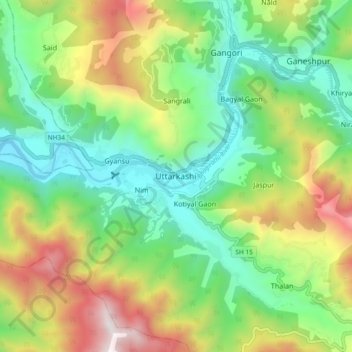
Name: Uttarkashi topographic map, elevation, terrain.

Location: Uttarkashi, Bhatwari, Uttarkashi District, Uttarakhand, 249193, India (30.68910 78.40035 30.76910 78.48035)

Average elevation: 1,619 m

Minimum elevation: 1,052 m

Maximum elevation: 2,642 m

It is the district headquarters of Uttarkashi district. Uttarkashi is situated on the banks of river Bhagirathi at an altitude of 1158 m above sea level. Uttarkashi is generally known as a holy town close to Rishikesh. It is located in the state of Uttarakhand in India. Uttarkashi is home to a number of ashrams and temples and also to the Nehru Institute of Mountaineering. The name of the town reflects its similarity to and location (as north of) the city of Kashi (Varanasi). Similar to Varanasi, town of Uttarkashi is situated on the Ganges, lies next to a hill named Varunavat, on confluence of two rivers Varuna and Asi, has a ghat called Manikarnika Ghat and has a temple dedicated to Shiva similar to (Kashi Vishwanath Temple) in Varanasi, in the center of the town.

Wikipedia (CC-BY-SA 3.0)

Other topographic maps

Click on a map to view its topography, its elevation and its terrain.

Bagori

India > Uttarakhand > Bhatwari

Bagori, Bhatwari, Uttarkashi District, Uttarakhand, India

Average elevation: 2,955 m

Taknaur Renge

India > Uttarakhand > Bhatwari

Taknaur Renge, Bhatwari, Uttarkashi District, Uttarakhand, India

Average elevation: 1,811 m

Salang

India > Uttarakhand > Bhatwari

Salang, Bhatwari, Uttarkashi District, Uttarakhand, India

Average elevation: 2,172 m

Malla

India > Uttarakhand > Bhatwari

Malla, Bhatwari, Uttarkashi district, Uttarakhand, India

Average elevation: 1,911 m

Raithal

India > Uttarakhand > Bhatwari

Raithal, Bhatwari, Uttarkashi district, Uttarakhand, India

Average elevation: 2,122 m

Dharali

India > Uttarakhand > Bhatwari > Dharali

Dharali, Bhatwari, Uttarkashi district, Uttarakhand, India

Average elevation: 2,963 m

Harsil

India > Uttarakhand > Bhatwari

Harsil, Bhatwari, Uttarkashi district, Uttarakhand, India

Average elevation: 2,761 m

Mandav

India > Uttarakhand > Bhatwari > Uttarkashi > Mandav

Mandav, Uttarkashi, Bhatwari, Uttarkashi district, Uttarakhand, 249193, India

Average elevation: 1,495 m

Meru North

India > Uttarakhand > Bhatwari

Meru North, Bhatwari, Uttarkashi, Uttarakhand, India

Average elevation: 5,744 m

Sungar

India > Uttarakhand > Bhatwari > Sungar

Sungar, Bhatwari, Uttarkashi, Uttarakhand, 249135, India

Average elevation: 2,433 m

Gangotri

India > Uttarakhand > Bhatwari

Gangotri, Bhatwari, Uttarkashi District, Uttarakhand, India

Average elevation: 4,139 m