
Genesee County topographic map
Interactive map
Click on the map to display elevation.
About this map
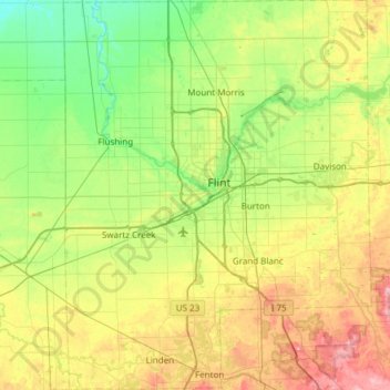
Name: Genesee County topographic map, elevation, terrain.
Location: Genesee County, Michigan, United States (42.78077 -83.93207 43.22312 -83.45330)
Average elevation: 246 m
Minimum elevation: 184 m
Maximum elevation: 370 m
Other topographic maps
Click on a map to view its topography, its elevation and its terrain.
Sears
United States > Michigan > Osceola County
Sears, Orient Township, Osceola County, Michigan, 49679, United States
Average elevation: 322 m
Negaunee
United States > Michigan > Marquette County
Negaunee, Marquette County, Michigan, 49866, United States
Average elevation: 441 m
Epsilon
United States > Michigan > Emmet County
Epsilon, Springvale Township, Emmet County, Michigan, United States
Average elevation: 230 m
Sturgeon Falls
United States > Michigan > Houghton County
Sturgeon Falls, Laird Township, Houghton County, Michigan, United States
Average elevation: 328 m
Westland
United States > Michigan > Wayne County
Westland, Wayne County, Michigan, United States
Average elevation: 202 m
Marengo Township
United States > Michigan > Calhoun County
Marengo Township, Calhoun County, Michigan, United States
Average elevation: 288 m
Onota Township
United States > Michigan > Alger County > Onota Township
Onota Township, Alger County, Michigan, 49822, United States
Average elevation: 228 m
Kalamazoo
United States > Michigan > Kalamazoo County > Kalamazoo
Kalamazoo, Kalamazoo County, Michigan, United States
Average elevation: 265 m
Flint
United States > Michigan > Genesee County > Flint
Flint, Genesee County, Michigan, United States
Average elevation: 236 m
Lansing
United States > Michigan > Ingham County > Lansing
Lansing, Ingham County, Michigan, United States
Average elevation: 263 m
Marquette County
United States > Michigan > Marquette County
Marquette County, Michigan, United States
Average elevation: 332 m
Oakfield Township
United States > Michigan > Kent County
Oakfield Township, Kent County, Michigan, United States
Average elevation: 265 m
Green Haven
United States > Michigan > Green Haven
Green Haven, Burt Township, Alger County, Michigan, United States
Average elevation: 283 m
East Lansing
United States > Michigan > Ingham County
East Lansing, Ingham County, Michigan, United States
Average elevation: 261 m