
Thank you for supporting this site ❤️
Make a donation
Make a donation
Lansing topographic map
Click on the map to display elevation.
Thank you for supporting this site ❤️
Make a donation
Make a donation
Lansing
Lansing elevations range between 890 feet (271 m) above sea level on the far south side of Lansing along Northrup Street near the Cedar Street intersection, to 833 feet (254 m) to 805.5 feet (246 m) above sea level along the Grand River.
Thank you for supporting this site ❤️
Make a donation
Make a donation
About this map
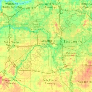
Name: Lansing topographic map, elevation, terrain.
Location: Lansing, Ingham County, Michigan, United States (42.64748 -84.70128 42.79498 -84.41758)
Average elevation: 263 m
Minimum elevation: 239 m
Maximum elevation: 294 m
Thank you for supporting this site ❤️
Make a donation
Make a donation