
Ingham County topographic map
Interactive map
Click on the map to display elevation.
About this map
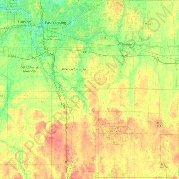
Name: Ingham County topographic map, elevation, terrain.
Location: Ingham County, Michigan, United States (42.42196 -84.60314 42.77660 -84.14060)
Average elevation: 278 m
Minimum elevation: 246 m
Maximum elevation: 319 m
The county consists of gently rolling hills with an elevation ranging between 800 and 1,000 feet above sea level. The highest point in the county is the top of Teaspoon Hill rising to a height of 1,056 feet above sea level 1.5 miles north of Leslie.
Other topographic maps
Click on a map to view its topography, its elevation and its terrain.
Sears
United States > Michigan > Osceola County
Sears, Orient Township, Osceola County, Michigan, 49679, United States
Average elevation: 322 m
Negaunee
United States > Michigan > Marquette County
Negaunee, Marquette County, Michigan, 49866, United States
Average elevation: 441 m
Epsilon
United States > Michigan > Emmet County
Epsilon, Springvale Township, Emmet County, Michigan, United States
Average elevation: 230 m
Sturgeon Falls
United States > Michigan > Houghton County
Sturgeon Falls, Laird Township, Houghton County, Michigan, United States
Average elevation: 328 m
Westland
United States > Michigan > Wayne County
Westland, Wayne County, Michigan, United States
Average elevation: 202 m
Marengo Township
United States > Michigan > Calhoun County
Marengo Township, Calhoun County, Michigan, United States
Average elevation: 288 m
Onota Township
United States > Michigan > Alger County > Onota Township
Onota Township, Alger County, Michigan, 49822, United States
Average elevation: 228 m
Kalamazoo
United States > Michigan > Kalamazoo County > Kalamazoo
Kalamazoo, Kalamazoo County, Michigan, United States
Average elevation: 265 m
Flint
United States > Michigan > Genesee County > Flint
Flint, Genesee County, Michigan, United States
Average elevation: 236 m
Lansing
United States > Michigan > Ingham County > Lansing
Lansing, Ingham County, Michigan, United States
Average elevation: 263 m
Marquette County
United States > Michigan > Marquette County
Marquette County, Michigan, United States
Average elevation: 332 m
Oakfield Township
United States > Michigan > Kent County
Oakfield Township, Kent County, Michigan, United States
Average elevation: 265 m
Green Haven
United States > Michigan > Green Haven
Green Haven, Burt Township, Alger County, Michigan, United States
Average elevation: 283 m
Genesee County
Genesee County, Michigan, United States
Average elevation: 246 m
East Lansing
United States > Michigan > Ingham County
East Lansing, Ingham County, Michigan, United States
Average elevation: 261 m