Geolocate

Chikkamagaluru taluku topographic map

Interactive map

Click on the map to display elevation.

About this map

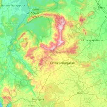
Name: Chikkamagaluru taluku topographic map, elevation, terrain.

Location: Chikkamagaluru taluku, Chikkamagaluru, Karnataka, India (13.16576 75.48781 13.56623 76.04432)

Average elevation: 946 m

Minimum elevation: 593 m

Maximum elevation: 1,880 m

Other topographic maps

Click on a map to view its topography, its elevation and its terrain.

Devanahalli

India > Karnataka > Devanahalli taluku

Average elevation: 900 m

Mysuru

India > Karnataka > Mysuru taluk

Mysore (/maɪˈsɔːr/ (listen)), officially Mysuru ([ˈmaɪˈsuːɾu] (listen)), is a city in the southern part of the state of Karnataka, India. Mysore city is geographically located between 12° 18′ 26″ north latitude and 76° 38′ 59″ east longitude. It is located at an altitude of 770 m (2,530 ft)…

Average elevation: 727 m

Baruru

India > Karnataka > Shirasi taluk

Average elevation: 557 m

Udupi

India > Karnataka > Udupi taluku

Udupi has an elevation of 27 m (89 ft) above mean sea level. The climate in Udupi is hot in summers and pleasant in winter. During summers (from March to May) the temperature reaches up to 38 °C (100 °F) and in winters (from December to February) it is usually between 32 and 20 °C (90 and 68 °F). As it is…

Average elevation: 17 m

Chikkamagaluru

India > Karnataka > Chikkamagaluru taluku

Chikmagalur is situated in the Malenadu region of Karnataka in the Deccan plateau in the foothills of the Western Ghats. It is situated at an elevation of 1,090 metres (3,580 ft) above mean sea level, meaning it is the third highest city in Karnataka. The Yagachi River has its source near the town and flows in…

Average elevation: 1,052 m

Suttagatti

India > Karnataka > Hubballi Urban Taluku

Average elevation: 684 m

Amaragol

India > Karnataka > Hubballi Urban Taluku

Average elevation: 670 m

Bylakuppe

India > Karnataka > Piriyapattana taluk

Average elevation: 859 m

Basarikatte

India > Karnataka > Belagavi taluku

Average elevation: 771 m

Indrasanahalli

India > Karnataka > Devanahalli taluku

Average elevation: 919 m

Kadaba

India > Karnataka > Gubbi taluk

Average elevation: 770 m

Ballari

India > Karnataka > Bellary taluk

Average elevation: 471 m

Ullala

India > Karnataka > Shirasi taluk

Average elevation: 622 m

Mani - Mysore Road

India > Karnataka > Madikeri taluku > Madikeri

Average elevation: 1,074 m

Anamod

India > Karnataka > Supa taluk

Average elevation: 647 m

Chikodi Road

India > Karnataka > Chikodi taluk

Average elevation: 653 m

Mangaluru

India > Karnataka > Mangaluru taluk

Mangalore is also the administrative headquarters of the Dakshina Kannada district; it is a commercial, industrial, educational, healthcare, and startup hub. The city's international airport is the second-largest and second-busiest airport in Karnataka. Mangalore City Corporation is responsible for the civic…

Average elevation: 25 m

Nagawara Lake

India > Karnataka > Bangalore North > Bengaluru

Average elevation: 896 m

Madduru

India > Karnataka > Mysuru taluk

Average elevation: 706 m

Hunagund

India > Karnataka > Hunagunda taluku

Average elevation: 543 m

Kesavinamane

India > Karnataka > Chikkamagaluru taluku

Average elevation: 1,319 m

Hachchinadu

India > Karnataka > Madikeri taluku

Average elevation: 1,017 m

Soraba

India > Karnataka > Soraba taluk

Average elevation: 601 m

Hadinaru

India > Karnataka > Nanjanagudu taluk

Average elevation: 665 m

Chikkamagaluru

India > Karnataka > Chikkamagaluru taluku

Chikmagalur is situated in the Malenadu region of Karnataka in the Deccan plateau in the foothills of the Western Ghats. It is situated at an elevation of 1,090 metres (3,580 ft) above mean sea level, meaning, it is the third highest city in Karnataka. The Yagachi River has its source near the town and flows…

Average elevation: 1,052 m

Hanur

India > Karnataka > Hanur taluk

Average elevation: 673 m

Kaluru

India > Karnataka > Madikeri taluku

Average elevation: 998 m

Arikere

India > Karnataka > Srinivasapura taluku

Average elevation: 828 m

Somavarapete

India > Karnataka > Chamarajanagara taluk

Average elevation: 721 m

Tolasani

India > Karnataka > Honnavar taluku

Average elevation: 235 m

Chikkodi

India > Karnataka > Chikodi taluk

Average elevation: 671 m

Urdigere

India > Karnataka > Tumkur taluk

Average elevation: 891 m

Markal

India > Karnataka > Sringeri taluku

Average elevation: 701 m

Arikere

India > Karnataka > Srinivasapura taluku

Average elevation: 828 m

Markal

India > Karnataka > Sringeri taluku

Average elevation: 701 m

Kalaburagi

India > Karnataka > Kalaburagi taluku

The entire district is on the Deccan Plateau, and the elevation ranges from 300 to 750 m above MSL. Two main rivers, the Krishna and Bhima, flow through the district. The predominant soil type is black soil. The district has many tanks, which irrigate the land along with the river. The Upper Krishna Project is…

Average elevation: 465 m

Gundapura

India > Karnataka > Hanur taluk

Average elevation: 676 m

Nagondanahalli

India > Karnataka > Bangalore East

Average elevation: 868 m

Mysuru

India > Karnataka > Mysuru taluk

Mysore (/maɪˈsɔːr/ (listen)), officially Mysuru ([ˈmaɪˈsuːɾu] (listen)), is a city in the southern part of the state of Karnataka, India. Mysore city is geographically located between 12° 18′ 26″ north latitude and 76° 38′ 59″ east longitude. It is located at an altitude of 770 m (2,530 ft)…

Average elevation: 727 m

Kesavinamane

India > Karnataka > Chikkamagaluru taluku

Average elevation: 1,319 m

Marandahalli

India > Karnataka > Mulubagilu taluk

Average elevation: 775 m

Mahal Chaudadenahalli

India > Karnataka > Anekal

Average elevation: 868 m

Sangura

India > Karnataka > Haveri taluku

Average elevation: 544 m

Gattahalli

India > Karnataka > Anekal

Average elevation: 902 m

Bengaluru

India > Karnataka > Bangalore North

Bangalore (/ˈbæŋɡəlɔːr, ˌbæŋɡəˈlɔːr/ BANG-gə-lor, -⁠LOR), officially Bengaluru (Kannada: [ˈbeŋɡɐɭuːɾu] ; ISO: Beṁgaḷūru), is the capital and largest city of the southern Indian state of Karnataka. It has a population of more than 8 million and a metropolitan population of around…

Average elevation: 879 m

Chamundipuram

India > Karnataka > Mysuru taluk

Average elevation: 782 m

Hubli

India > Karnataka > Hubballi Urban Taluku

Average elevation: 626 m

Sarjapura

India > Karnataka > Anekal

Average elevation: 882 m

Konnur

India > Karnataka > Gokak taluku

Average elevation: 622 m

Nagarbhavi Lake

India > Karnataka > Bangalore North > Bengaluru

Average elevation: 853 m

Hubli

India > Karnataka > Hubballi Urban Taluku

Average elevation: 626 m

Sulikunte

India > Karnataka > Bangarapet taluk

Average elevation: 861 m

Bangarapete

India > Karnataka > Bangarapet taluk

Average elevation: 829 m

Minakunte Hosuru

India > Karnataka > Yelahanka taluku

Average elevation: 910 m

Mamadapura

India > Karnataka > Shiggaon taluk

Average elevation: 660 m

Chikkamagaluru

India > Karnataka > Chikkamagaluru taluku

Chikmagalur is situated in the Malenadu region of Karnataka in the Deccan plateau in the foothills of the Western Ghats. It is situated at an elevation of 1,090 metres (3,580 ft) above mean sea level, meaning, it is the third highest city in Karnataka. The Yagachi River has its source near the town and flows…

Average elevation: 1,052 m

Sambra

India > Karnataka > Belagavi taluku

Average elevation: 742 m

Ilkal

India > Karnataka > Ilkal taluka

Average elevation: 575 m

Bagalkote

India > Karnataka > Bagalakote taluk

Bagalkote, is a city in the state of Karnataka, India, which is also the headquarters of Bagalkot district. It is situated on branch of River Ghataprabha, The population of the urban agglomeration was 111,933 according to the provisional results of 2011 national census of India, the city is spread over an area…

Average elevation: 556 m

Sadenahalli

India > Karnataka > Chikkaballapura taluk

Average elevation: 1,007 m

Puttur

India > Karnataka > Putturu taluk

Puttur is located at 12°45′53″N 75°11′03″E / 12.7648°N 75.1842°E / 12.7648; 75.1842. It has an average elevation of 87 m (300 ft). Puttur is situated 52 km (32 mi) south-east of Mangalore city.

Average elevation: 110 m

Bodana Hosahalli

India > Karnataka > Hosakote taluk

Average elevation: 874 m

Vastare

India > Karnataka > Chikkamagaluru taluku

Average elevation: 1,090 m

Junnasandra

India > Karnataka > Bangalore East > Doddakannalli

Average elevation: 892 m

Bhuvanahalli

India > Karnataka > Devanahalli taluku

Average elevation: 900 m

Birasandra

India > Karnataka > Devanahalli taluku

Average elevation: 923 m

Hosakere

India > Karnataka > Tirthahalli taluk

Average elevation: 646 m

Prakash Nagar

India > Karnataka > Hosapete taluk > Hampi

Average elevation: 435 m

Kalligudda

India > Karnataka > Hunagunda taluku

Average elevation: 529 m

Toravalli

India > Karnataka > Gundlupet taluk

Average elevation: 722 m

Sarjapura

India > Karnataka > Anekal

Average elevation: 882 m

Alanda

India > Karnataka > Alanda taluku

Aland is situated at coordinates 17°34′N 76°34′E / 17.57°N 76.57°E / 17.57; 76.57, with an average elevation of 480 metres (1,570 ft) AMSL. The town covers an area of 8 square kilometres (3.1 sq mi).

Average elevation: 516 m

Mandagadde

India > Karnataka > Tirthahalli taluk

Average elevation: 615 m

Tivoli

India > Karnataka > Khanapura taluku

Average elevation: 674 m

Junnasandra

India > Karnataka > Bangalore East > Doddakannalli

Average elevation: 892 m

Hosakote

India > Karnataka > Virajpet taluk

Average elevation: 887 m

Bandapura

India > Karnataka > Bangalore East

Average elevation: 879 m

Shivamogga

India > Karnataka > Shivamogga taluk

Average elevation: 634 m

Kallumotte

India > Karnataka > Madikeri taluku

Average elevation: 886 m

Mukkodlu

India > Karnataka > Madikeri taluku

Average elevation: 1,070 m

Nagondanahalli

India > Karnataka > Bangalore East

Average elevation: 868 m

Doddaballapura

India > Karnataka > Doddaballapura taluk

Average elevation: 899 m

Mysore Palace

India > Karnataka > Mysuru taluk > Mysuru

Average elevation: 747 m

Manipal Lake

India > Karnataka > Udupi taluku > Manipal

Average elevation: 63 m

Tailagere

India > Karnataka > Devanahalli taluku

Average elevation: 946 m

Devagiri

India > Karnataka > Belagavi taluku

Average elevation: 748 m

Minakanagurki

India > Karnataka > Gauribidanuru taluk

Average elevation: 760 m

Sadaramangala

India > Karnataka > Bangalore East

Average elevation: 880 m

Karahalli

India > Karnataka > Devanahalli taluku

Average elevation: 936 m

Aurada

India > Karnataka > Aurad taluku

Aurad is located at 18°15′N 77°26′E / 18.25°N 77.43°E / 18.25; 77.43. It has an average elevation of 542 metres (1,778 ft). Aurad is 840 kilometres (520 mi) from Bengaluru and 42 kilometres (26 mi) from District Headquarters Bidar. The area of Aurad taluka is 1,227.20 km2 having 6 circles, 149…

Average elevation: 553 m

Belagavi

India > Karnataka > Belagavi taluku

Belgaum is located at 15°52′N 74°30′E / 15.87°N 74.5°E / 15.87; 74.5. It has an average elevation of 751 metres (2,464 feet). The city is in the northwestern parts of Karnataka and lies at the border of two states, Maharashtra and Goa on the western ghats (50 km (31 mi) from the Goa state…

Average elevation: 760 m

Chorla

India > Karnataka > Khanapura taluku

Average elevation: 662 m

Samse

India > Karnataka > Kalasa taluk

Average elevation: 888 m

Upaloon

India > Karnataka > Kalaburagi taluku > Kalaburagi

Average elevation: 472 m

Pavagada

India > Karnataka > Pavagada taluk > Pavagada

Average elevation: 658 m

Hampi

India > Karnataka > Hosapete taluk

Average elevation: 436 m