
Make a donation
Aurada topographic map
Click on the map to display elevation.
Make a donation
Aurada
Aurad is located at 18°15′N 77°26′E / 18.25°N 77.43°E / 18.25; 77.43. It has an average elevation of 542 metres (1,778 ft). Aurad is 840 kilometres (520 mi) from Bengaluru and 42 kilometres (26 mi) from District Headquarters Bidar. The area of Aurad taluka is 1,227.20 km2 having 6 circles, 149 villages and 177 thandas. It is located 542–610 metres (1,778–2,001 ft) above sea level. Aurad is the largest of the five talukas in Bidar District.
Make a donation
About this map
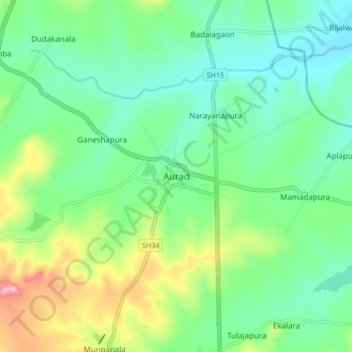
Name: Aurada topographic map, elevation, terrain.
Location: Aurada, Aurad taluku, Bidar, Karnataka, 585259, India (18.21486 77.37517 18.29486 77.45517)
Average elevation: 553 m
Minimum elevation: 502 m
Maximum elevation: 673 m
Make a donation
Other topographic maps
Click on a map to view its topography, its elevation and its terrain.