
Caspian Sea topographic map
Interactive map
Click on the map to display elevation.
Caspian Sea
Over 130 rivers provide inflow to the Caspian, with the Volga River being the largest. A second affluent, the Ural River, flows in from the north, and the Kura River flows into the sea from the west. In the past, the Amu Darya (Oxus) of Central Asia in the east often changed course to empty into the Caspian through a now-desiccated riverbed called the Uzboy River, as did the Syr Darya farther north. The Caspian has several small islands; they are primarily located in the north and have a collective land area of roughly 2,000 km2 (770 sq mi). Adjacent to the North Caspian is the Caspian Depression, a low-lying region 27 metres (89 ft) below sea level. The Central Asian steppes stretch across the northeast coast, while the Caucasus mountains hug the western shore. The biomes to both the north and east are characterized by cold, continental deserts. Conversely, the climate to the southwest and south are generally warm with uneven elevation due to a mix of highlands and mountain ranges; the drastic changes in climate alongside the Caspian have led to a great deal of biodiversity in the region.
About this map
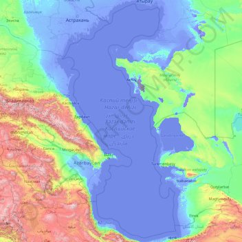
Name: Caspian Sea topographic map, elevation, terrain.
Location: Caspian Sea (36.57197 46.73944 46.98634 54.13888)
Average elevation: 390 m
Minimum elevation: -130 m
Maximum elevation: 4,335 m
Other topographic maps
Click on a map to view its topography, its elevation and its terrain.
Mangaluru
India > Karnataka > Mangaluru taluk
Mangalore is also the administrative headquarters of the Dakshina Kannada district; it is a commercial, industrial, educational, healthcare, and startup hub. The city's international airport is the second-largest and second-busiest airport in Karnataka. Mangalore City Corporation is responsible for the civic…
Average elevation: 25 m
Thiruvananthapuram
India > Kerala > Thiruvananthapuram
Thiruvananthapuram is built on seven hills by the seashore and is at 8°30′N 76°54′E / 8.5°N 76.9°E / 8.5; 76.9 on the west coast, near the southern tip of mainland India. The city is on the west coast of India and is bounded by the Laccadive Sea to its west and the Western Ghats to its east.…
Average elevation: 33 m
Vadodara
India > Gujarat > Vadodara Rural Taluka
Vadodara is located at 22°18′N 73°11′E / 22.30°N 73.19°E / 22.30; 73.19 in western India at an elevation of 39 metres (128 ft). It is the tenth-largest city in India with an area of 400 square kilometres (150 sq mi) and a population of 3.5 million, according to the 2010–11 census. The city…
Average elevation: 36 m
Tallahassee
United States > Florida > Leon County > Tallahassee
Tallahassee's terrain is hilly by Florida standards, being at the southern end of the Red Hills Region, just above the Cody Scarp. The elevation varies from near sea level to just over 200 feet (61 m), with the state capitol on one of the highest hills in the city. The city includes two large lake basins, Lake…
Average elevation: 32 m
Kandy
Kandy is located in the mountainous and thickly forested interior of the island. The city is located in between multiple mountain ranges including the Knuckles mountain range and the Hanthana Mountain Range, giving the city an elevation of 500 metres (1,600 ft) above sea level. It lies adjacent to the…
Average elevation: 621 m
Dehradun
India > Uttarakhand > Dehradun
The city of Dehradun mainly lies in Doon Valley and is at a varying height from 410 m (1,350 ft) in Clement Town to above 700 m (2,300 ft) at Malsi which is 15 km (9.3 mi) from the city. However, the average elevation is 450 m (1,480 ft) above sea level. Malsi is the starting point of Lesser Himalayan Range…
Average elevation: 904 m
Navi Mumbai
India > Maharashtra > Thane > Navi Mumbai
Navi Mumbai (Marathi pronunciation: , also known by its former name New Bombay), is a planned city off the west coast of the Indian state of Maharashtra in Konkan division. The city is divided into two parts, North Navi Mumbai and South Navi Mumbai, for the individual development of Panvel Mega City, which…
Average elevation: 30 m
Surat
India > Gujarat > Katargam Taluka > Surat
Surat is a port city situated on the banks of the Tapi river. Damming of the Tapi caused the original port facilities to close; the nearest port is now in the Magadalla and Hazira area of Surat Metropolitan Region.It has famous beach called 'Dumas Beach' located in Hazira. The city is located at 21°10′N…
Average elevation: 11 m
Salem
Salem is located at 11°40′N 78°08′E / 11.67°N 78.14°E / 11.67; 78.14, at an average elevation of 278 m (912 ft). The city is surrounded by hills: Nagaramalai on the north, Jarugumalai on the south, Kanjamalai on the west, Godumalai on the east and the Shevaroy Hills on the northeast.…
Average elevation: 418 m
Karkala
India > Karnataka > Karkala taluk
Karla is located at 13°12′N 74°59′E / 13.2°N 74.98°E / 13.2; 74.98. It has an average elevation of 81 metres (265 feet).
Average elevation: 80 m
Gharaunda
Gharaunda is located at 29°32′N 76°58′E / 29.54°N 76.97°E / 29.54; 76.97. It has an average elevation of 213 metres (698 feet). The municipal area of the town is 4.37 km² which does not include the existing and proposed area to be developed by Haryana Urban Development Authority under any…
Average elevation: 242 m
Dhari
India > Gujarat > Dhari Taluka
Dhari is located at 21°19′36″N 71°01′31″E / 21.3266°N 71.0253°E / 21.3266; 71.0253. It has an average elevation of 216m (708') above sea level. The city is located in Saurashtra region of Gujarat and is situated near the Shetrunji River, which is passes north of Palitana's hills,…
Average elevation: 221 m
Udaipur
India > Rajasthan > Girwa Tehsil
Udaipur is located at 24°31′30″N 73°40′38″E / 24.525049°N 73.677116°E / 24.525049; 73.677116. The city covers an area of 64 km2 (25 sq mi) and lies at an altitude of 598.00 m (1,962 ft) above sea level. It is located in the southern region of Rajasthan, near the Gujarat border. The city…
Average elevation: 656 m
Sunshine Coast
Australia > Queensland > Maroochydore
The Sunshine Coast in Queensland, Australia, showcases a diverse topography that harmoniously blends coastal plains with rugged hinterlands. Along its eastern edge, the region features expansive sandy beaches and coastal dunes that transition smoothly into fertile lowlands. Inland, the terrain becomes more…
Average elevation: 7 m
Ankara
Ankara has a cold semi-arid climate (Köppen climate classification: BSk). Under the Trewartha climate classification, Ankara has a temperate humid continental climate (Dc). Due to its elevation and inland location, Ankara has cold and snowy winters, and hot and dry summers. Rainfall occurs mostly during the…
Average elevation: 1,082 m
Varanasi
India > Uttar Pradesh > Sadar
Varanasi is located at an elevation of 80.71 metres (264.8 ft) in the centre of the Ganges valley of North India, in the Eastern part of the state of Uttar Pradesh, along the left crescent-shaped bank of the Ganges, averaging between 15 metres (50 ft) and 21 metres (70 ft) above the river. The city is the…
Average elevation: 77 m
Arthur Seat
Canada > British Columbia > Thompson-Nicola Regional District > Area I (Blue Sky Country)
Average elevation: 1,327 m
Mysuru
India > Karnataka > Mysuru taluk
Mysore (/maɪˈsɔːr/ (listen)), officially Mysuru ([ˈmaɪˈsuːɾu] (listen)), is a city in the southern part of the state of Karnataka, India. Mysore city is geographically located between 12° 18′ 26″ north latitude and 76° 38′ 59″ east longitude. It is located at an altitude of 770 m (2,530 ft)…
Average elevation: 727 m