
Curaçao topographic map
Interactive map
Click on the map to display elevation.
About this map
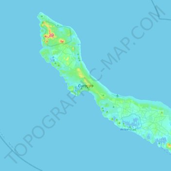
Name: Curaçao topographic map, elevation, terrain.
Location: Curaçao, Curacao, Netherlands (12.03427 -69.16271 12.39273 -68.73664)
Average elevation: 7 m
Minimum elevation: -1 m
Maximum elevation: 322 m
Curaçao, as well as the rest of the ABC islands and Trinidad and Tobago, lies on the continental shelf of South America. It is a thin island with a generally hilly topography; the highest point is Christoffelberg in the northwest, with a peak at 372 m (1,220 ft) above sea level. The coastline's bays, inlets and hot springs offer a source of natural minerals, thermal conditions, and seawater used in hydrotherapy and mesotherapy, making the island one of many balneoclimateric areas in the region. Off the southeast coast lies the small, flat island of Klein Curaçao.
Other topographic maps
Click on a map to view its topography, its elevation and its terrain.
Zoetermeer
Netherlands > South Holland > Zoetermeer
Zoetermeer, South Holland, Netherlands
Average elevation: -3 m
Emmeloord
Emmeloord, Noordoostpolder, Flevoland, Netherlands
Average elevation: -3 m
Het Loo
Netherlands > Overijssel > Wierden
Het Loo, Wierden, Overijssel, Netherlands, 7641 PP, Netherlands
Average elevation: 12 m
Zoute
Netherlands > Zeeland > Yerseke
Zoute, Yerseke, Reimerswaal, Zeeland, Netherlands, 4401 NG, Netherlands
Average elevation: -1 m
's-Hertogenbosch
's-Hertogenbosch, North Brabant, Netherlands
Average elevation: 4 m
Hoogerheide
Hoogerheide, Woensdrecht, North Brabant, Netherlands
Average elevation: 12 m
Sloten
Netherlands > North Holland > Amsterdam
Sloten, Amsterdam, North Holland, Netherlands, 1066 CZ, Netherlands
Average elevation: 0 m
Philipsburg
Philipsburg, Country of Sint Maarten, 721, Netherlands
Average elevation: 33 m
Groningen
Netherlands > Groningen > Groningen
Groningen, Netherlands, 9712HS, Netherlands
Average elevation: 2 m
Eindhoven
Netherlands > North Brabant > Eindhoven
Eindhoven, North Brabant, Netherlands, 5611EB, Netherlands
Average elevation: 21 m
Leeuwarden
Netherlands > Frisia > Leeuwarden
Leeuwarden, Frisia, Netherlands, 8911BR, Netherlands
Average elevation: 0 m
Zwijndrecht
Netherlands > South Holland > Zwijndrecht
Zwijndrecht, South Holland, Netherlands
Average elevation: 1 m
Kralendijk
Kralendijk, Bonaire, Netherlands, 1234AB, Netherlands
Average elevation: 9 m
Zaandam
Netherlands > North Holland > Zaandam
Zaandam, Zaanstad, North Holland, Netherlands
Average elevation: 0 m
558
Netherlands > Zeeland > Kamperland
558, Kamperland, Noord-Beveland, Zeeland, Netherlands
Average elevation: 0 m
Spijkenisse
Spijkenisse, Nissewaard, South Holland, Netherlands
Average elevation: 1 m
Camping
Netherlands > Friesland > De Fryske Marren
Camping, De Fryske Marren, Friesland, Netherlands, 8493KN, Netherlands
Average elevation: -1 m