
Thank you for supporting this site ❤️
Make a donation
Make a donation
Overijssel topographic map
Click on the map to display elevation.
Thank you for supporting this site ❤️
Make a donation
Make a donation
About this map
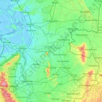
Name: Overijssel topographic map, elevation, terrain.
Location: Overijssel, Netherlands (52.11807 5.77775 52.85422 7.07276)
Average elevation: 15 m
Minimum elevation: -5 m
Maximum elevation: 109 m
Thank you for supporting this site ❤️
Make a donation
Make a donation
Other topographic maps
Click on a map to view its topography, its elevation and its terrain.