
Make a donation
Rincon topographic map
Click on the map to display elevation.
Make a donation
About this map
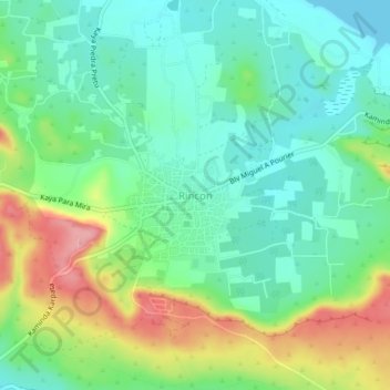
Name: Rincon topographic map, elevation, terrain.
Location: Rincon, Bonaire, Netherlands (12.21867 -68.34982 12.25867 -68.30982)
Average elevation: 40 m
Minimum elevation: 0 m
Maximum elevation: 119 m
Make a donation
Other topographic maps
Click on a map to view its topography, its elevation and its terrain.
Make a donation
Make a donation
Make a donation
Make a donation
Saba
There is an 8.6 hectares (21 acres) cloud forest located at and above 825 metres (2,707 ft) on top of the mountain referred to as the "Elfin Forest Reserve" because of its high altitude mist and mossy appearance. The most dominant tree in the cloud forest is the Mountain Mahogany (Freziera undulate), although…
Average elevation: 2 m
Make a donation
Sint Eustatius
Sint Eustatius is 6 miles (10 km) long and up to 3 miles (5 km) wide. Topographically, the island is saddle-shaped, with the 602-meter-high dormant volcano Quill (Mount Mazinga), (from Dutch kuil, meaning 'pit'—originally referring to its crater) to the southeast and the smaller summits of Signal Hill/Little…
Average elevation: 12 m
Make a donation
Make a donation
Curaçao
Curaçao, as well as the rest of the ABC islands and Trinidad and Tobago, lies on the continental shelf of South America. It is a thin island with a generally hilly topography; the highest point is Christoffelberg in the northwest, with a peak at 372 m (1,220 ft) above sea level. The coastline's bays, inlets…
Average elevation: 7 m
Breda
Netherlands > North Brabant > Breda
Topographic map image of the city of Breda, March 2014. Click to enlarge.
Average elevation: 7 m
Make a donation