
Thank you for supporting this site ❤️
Make a donation
Make a donation
Schagen topographic map
Click on the map to display elevation.
Thank you for supporting this site ❤️
Make a donation
Make a donation
About this map
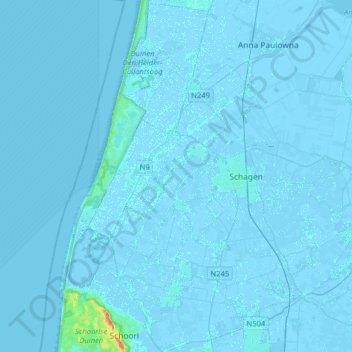
Name: Schagen topographic map, elevation, terrain.
Location: Schagen, North Holland, Netherlands (52.69140 4.63448 52.88447 4.85037)
Average elevation: 0 m
Minimum elevation: -6 m
Maximum elevation: 44 m
Thank you for supporting this site ❤️
Make a donation
Make a donation
Other topographic maps
Click on a map to view its topography, its elevation and its terrain.