
Jejuri topographic map
Interactive map
Click on the map to display elevation.
About this map
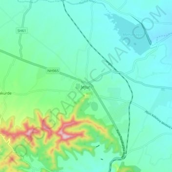
Name: Jejuri topographic map, elevation, terrain.
Location: Jejuri, Purandhar, Pune, Maharashtra, 412303, India (18.23690 74.12023 18.31690 74.20023)
Average elevation: 728 m
Minimum elevation: 659 m
Maximum elevation: 994 m
Jejuri is located at 18°17′N 74°10′E / 18.28°N 74.17°E / 18.28; 74.17. It has an average elevation of 718 metres (2355 feet) mean sea level.
Other topographic maps
Click on a map to view its topography, its elevation and its terrain.
Malhargad Fort
India > Maharashtra > Purandhar
Malhargad Fort, Malhargad Walking Path, Purandhar, Pune District, Maharashtra, India
Average elevation: 822 m
Garade
India > Maharashtra > Purandhar
Garade, Purandhar, Pune, Maharashtra, 412205, India
Average elevation: 883 m
Saswad
India > Maharashtra > Purandhar
Saswad, Purandhar, Pune, Maharashtra, 412300, India
Average elevation: 787 m
Narayanpur
India > Maharashtra > Purandhar
Narayanpur, Purandhar, Maharashtra, 412302, India
Average elevation: 924 m
Kalewadi
India > Maharashtra > Purandhar
Kalewadi, Purandhar, Pune, Maharashtra, India
Average elevation: 839 m
Ketkawale
India > Maharashtra > Purandhar
Ketkawale, Purandhar, Pune, Maharashtra, 412302, India
Average elevation: 754 m