
Make a donation
Hilders topographic map
Click on the map to display elevation.
Make a donation
About this map
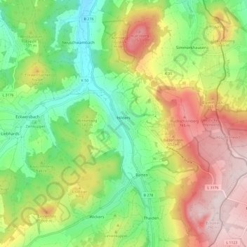
Name: Hilders topographic map, elevation, terrain.
Location: Hilders, Landkreis Fulda, Hessen, Deutschland (50.53385 9.98141 50.60707 10.05673)
Average elevation: 564 m
Minimum elevation: 389 m
Maximum elevation: 801 m
Make a donation
Other topographic maps
Click on a map to view its topography, its elevation and its terrain.
Bad Salzschlirf
Deutschland > Hessen > Landkreis Fulda
Bad Salzschlirf liegt in der Fuldaer Senke in 250 bis 495 Meter Höhe am Nordostrand des Vogelsbergs im Tal der Schlitz, die dort durch den Zusammenfluss von Lauter und Altefeld entsteht.
Average elevation: 313 m
Wasserkuppe
Deutschland > Hessen > Landkreis Fulda > Obernhausen
Die Wasserkuppe ist mit 950 m ü. NHN Höhe der höchste Berg der Rhön und zugleich die höchste Erhebung in Hessen. Sie liegt im Landkreis Fulda mit Gipfellage im Gebiet von Gersfeld.
Average elevation: 796 m
Make a donation
Fulda
Deutschland > Hessen > Landkreis Fulda > Fulda
Die Stadt Fulda liegt nahe der Mitte Deutschlands in Hessen; die Landesgrenzen zu Bayern und Thüringen liegen 15 km südsüdöstlich und 25 km östlich. Am Oberlauf des Flusses Fulda ist sie eingebettet in die Fuldaer Senke zwischen dem Fulda-Haune-Tafelland im Norden sowie den Mittelgebirgen Rhön im Osten…
Average elevation: 306 m
Make a donation
Flieden
Deutschland > Hessen > Landkreis Fulda
Der östliche Teil liegt nordwestlich des Landrückens, dem Bindeglied zwischen den Ausläufern des Vogelsbergs im Westen und der Rhön im Osten, im Fliedener Becken. Die südlichen Ortsteile liegen auf dem Landrücken, die westlichen gehören naturräumlich bereits zum unteren Vogelsberg. Diese…
Average elevation: 320 m
Großenlüder
Deutschland > Hessen > Landkreis Fulda
Großenlüder liegt in 245 bis 420 Meter Höhe an den östlichen Ausläufern des Vogelsberges. Höchste Erhebung der Gemeinde ist der Finkenberg mit 420 m. Auf diesem befand sich bis in die 1990er Jahre eine HAWK-Flugabwehrraketenstellung der US-Streitkräfte. Großenlüder liegt etwa elf Kilometer westlich von Fulda.
Average elevation: 295 m
Make a donation
Make a donation
Himmeldunkberg
Deutschland > Hessen > Landkreis Fulda > Mosbach
Über den Gipfel des Himmeldunkbergs verlaufen die Rhein-Weser-Wasserscheide, der Rhön-Höhen-Weg (RHW) und die Grenze zwischen Bayern und Hessen, wobei der genaue Gipfel wenige hundert Meter südlich der Grenze in Bayern liegt. Von der ehemaligen Grenze zwischen dem Königreich Bayern und dem Königreich…
Average elevation: 732 m
Make a donation
Make a donation
Schafstein
Deutschland > Hessen > Landkreis Fulda > Reulbach
Apfelbachaue bei Neuswarts | Auersberg nördlich Hilders | Bieberstein bei Langenbieber | Breitenbachtal bei Michelsrombach | Breiter Berg bei Haselstein | Brückenhut bei Dietges | Buchenberg, Grisselborner Wäldchen und Taftgrund bei Soisdorf | Eube | Fuldatal bei Eichenzell | Großes Moor bei Großenmoor |…
Average elevation: 742 m
Fürsteneck
Deutschland > Hessen > Landkreis Fulda > Eiterfeld > Fürsteneck
Die Höhenburg liegt im Hessischen Kegelspiel am Westrand der kleinen Hochebene Wittfeld. Sie befindet sich am Nordwestrand des 1,8 km nordnordöstlich vom Eiterfelder Kernort gelegenen Weilers Fürsteneck auf dem Hausberg (406,5 m ü. NHN).
Average elevation: 346 m
Make a donation
Milseburg
Deutschland > Hessen > Landkreis Fulda
Nachbarberge der Milseburg sind die etwa 1,5 km nördlich liegende Oberbernhardser Höhe (660,9 m) mit der Quelle des Scheppenbach-Zuflusses Dörmbach, der 1,2 km südöstlich gelegene Bubenbader Stein (758,8 m), der 2,9 km südlich befindliche Teufelstein (729,4 m) mit dem Quellgebiet der Bieber und der 1,9…
Average elevation: 619 m
Blankenau
Deutschland > Hessen > Landkreis Fulda > Blankenau
Blankenau, dessen Zentrum sich auf 280 m ü. NHN Höhe befindet, liegt im Westen des Landkreises Fulda unmittelbar an der Kreisgrenze zum Vogelsbergkreis. Geographisch wird das Dorf an den östlichen Ausläufern des Vogelsberges zum Fuldaer Graben, der die Rhön und den Vogelsberg voneinander trennt, dem…
Average elevation: 342 m
Make a donation
Burghaun
Deutschland > Hessen > Landkreis Fulda
Weiterhin gibt es die Weiler Klausmarbach, Mahlertshof und Hartmannshöhe, die keinen Status als Ortsteil haben.
Average elevation: 306 m
Make a donation
Abtsroda
Deutschland > Hessen > Landkreis Fulda > Abtsroda
Abtsroda ist ein kleiner Ort, der auf einer Höhe von ca. 650–700 m zwischen dem Weiherberg im Norden und der Wasserkuppe im Süden liegt. Der Ort hat rund 363 Einwohner und eine Fläche von 10,79 km². Im Westen liegen Sieblos, Tränkhof und Poppenhausen, im Osten Seiferts und Melperts. Nördlich liegen…
Average elevation: 694 m
Hosenfeld
Deutschland > Hessen > Landkreis Fulda > Hosenfeld
Hosenfeld, dessen Zentrum sich auf 374 m ü. NN Höhe befindet, liegt im Westen des Landkreises Fulda an den östlichen Ausläufern des Vogelsberges, etwa 19 Kilometer von der Kreisstadt Fulda entfernt.
Average elevation: 412 m
Make a donation
Make a donation
Wasserkuppe
Deutschland > Hessen > Landkreis Fulda > Obernhausen
Die Wasserkuppe ist mit 950 m ü. NHN Höhe der höchste Berg der Rhön und zugleich die höchste Erhebung in Hessen. Sie liegt im Landkreis Fulda mit Gipfellage im Gebiet von Gersfeld.
Average elevation: 796 m
Make a donation