
Thank you for supporting this site ❤️
Make a donation
Make a donation
Eichenzell topographic map
Click on the map to display elevation.
Thank you for supporting this site ❤️
Make a donation
Make a donation
About this map
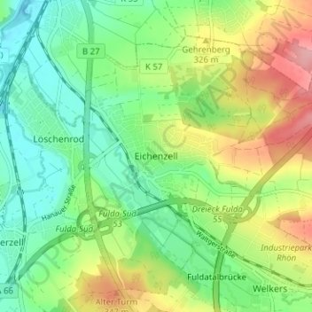
Name: Eichenzell topographic map, elevation, terrain.
Location: Eichenzell, Landkreis Fulda, Hessen, 36124, Deutschland (50.47577 9.67933 50.51577 9.71933)
Average elevation: 302 m
Minimum elevation: 256 m
Maximum elevation: 379 m
Thank you for supporting this site ❤️
Make a donation
Make a donation