
Lerchenküppel topographic map
Interactive map
Click on the map to display elevation.
About this map
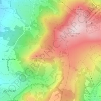
Name: Lerchenküppel topographic map, elevation, terrain.
Average elevation: 760 m
Minimum elevation: 569 m
Maximum elevation: 953 m
Other topographic maps
Click on a map to view its topography, its elevation and its terrain.
Tränkhof
Deutschland > Hessen > Landkreis Fulda > Abtsroda
Tränkhof, Abtsroda, Poppenhausen, Landkreis Fulda, Hessen, 36163, Deutschland
Average elevation: 591 m
Abtsroda
Deutschland > Hessen > Landkreis Fulda > Abtsroda
Abtsroda, Poppenhausen, Landkreis Fulda, Hessen, 36163, Deutschland
Average elevation: 694 m