
Thank you for supporting this site ❤️
Make a donation
Make a donation
Hermitage topographic map
Click on the map to display elevation.
Thank you for supporting this site ❤️
Make a donation
Make a donation
About this map
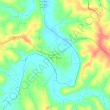
Name: Hermitage topographic map, elevation, terrain.
Location: Hermitage, Hickory County, Missouri, United States (37.93175 -93.35210 37.95284 -93.30578)
Average elevation: 250 m
Minimum elevation: 225 m
Maximum elevation: 289 m
Thank you for supporting this site ❤️
Make a donation
Make a donation
Other topographic maps
Click on a map to view its topography, its elevation and its terrain.