
Melchsee-Frutt topographic map
Interactive map
Click on the map to display elevation.
About this map
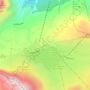
Name: Melchsee-Frutt topographic map, elevation, terrain.
Location: Melchsee-Frutt, Kerns, Obwalden, Schweiz (46.77242 8.26626 46.77672 8.27286)
Average elevation: 1,932 m
Minimum elevation: 1,458 m
Maximum elevation: 2,483 m
Other topographic maps
Click on a map to view its topography, its elevation and its terrain.
Engelberger Aa
Schweiz > Obwalden > Engelberg
Engelberger Aa, Engelberg, Obwalden, 6390, Schweiz
Average elevation: 1,129 m
Hochstollen
Hochstollen, Kerns, Obwalden, 6084, Schweiz
Average elevation: 2,000 m