
Fairbanks North Star topographic map
Interactive map
Click on the map to display elevation.
About this map
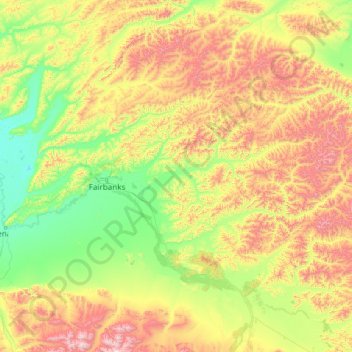
Name: Fairbanks North Star topographic map, elevation, terrain.
Location: Fairbanks North Star, Alaska, United States (64.25785 -148.66716 65.45448 -143.88478)
Average elevation: 528 m
Minimum elevation: 90 m
Maximum elevation: 2,247 m
Other topographic maps
Click on a map to view its topography, its elevation and its terrain.
Lituya Glacier
United States > Alaska > Unorganized Borough
It is partially responsible for creating the 1958 Lituya Bay megatsunami. The glacier, which has receded over the years, carved Lituya Bay into a unique topographic phenomenon with steep walls, a very deep submerged bottom, and a very narrow entrance to the ocean which created the opportunity for a megatsunami…
Average elevation: 952 m
Homer
United States > Alaska > Kenai Peninsula > Homer
Many of the birds seen during the festival can be identified with the help of published guides that categorize distinguishable features such as, topography, silhouette, size, and color.
Average elevation: 103 m