
Thank you for supporting this site ❤️
Make a donation
Make a donation
Yakutat topographic map
Click on the map to display elevation.
Thank you for supporting this site ❤️
Make a donation
Make a donation
About this map
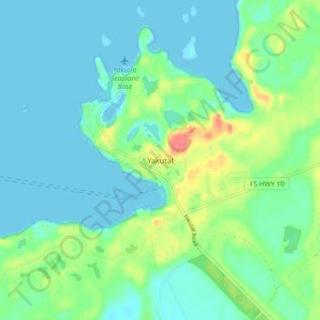
Name: Yakutat topographic map, elevation, terrain.
Location: Yakutat, Alaska, United States (59.53200 -139.75257 59.57200 -139.71257)
Average elevation: 14 m
Minimum elevation: -8 m
Maximum elevation: 56 m
Thank you for supporting this site ❤️
Make a donation
Make a donation
Other topographic maps
Click on a map to view its topography, its elevation and its terrain.
Hubbard Glacier
United States > Alaska > Yakutat
The longest source for Hubbard Glacier originates 122 kilometres (76 mi) from its snout and is located at about 61°00′N 140°09′W / 61.000°N 140.150°W / 61.000; -140.150, approximately 8 kilometres (5 mi) west of Mount Walsh with an elevation around 3,400 metres (11,200 ft). A shorter tributary…
Average elevation: 1,892 m