
Thank you for supporting this site ❤️
Make a donation
Make a donation
Aktobe Region topographic map
Click on the map to display elevation.
Thank you for supporting this site ❤️
Make a donation
Make a donation
About this map
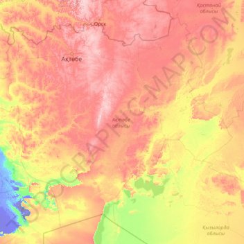
Name: Aktobe Region topographic map, elevation, terrain.
Location: Aktobe Region, Kazakhstan (45.17741 53.63054 51.31707 64.27717)
Average elevation: 146 m
Minimum elevation: -62 m
Maximum elevation: 624 m
Thank you for supporting this site ❤️
Make a donation
Make a donation
Other topographic maps
Click on a map to view its topography, its elevation and its terrain.
Qulsarı
Kazakhstan > Atyrau Region > Zhylyoi District > Құлсары қалалық әкімдігі
Average elevation: -11 m
Bulaq
Kazakhstan > North Kazakhstan Region > Esil District > Булакский сельский округ
Average elevation: 180 m
Border Kazakhstan - Russia
Kazakhstan > East Kazakhstan Region > Katonkaragay District
Average elevation: 2,676 m
Thank you for supporting this site ❤️
Make a donation
Make a donation